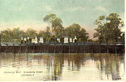
Wimmera River
- Wimmera River
-
37°16′29″S 143°15′00″E / -37.27472, 143.25
La Wimmera River est une rivière endoréique de l'ouest du Victoria, en Australie.
Géographie
Elle prend sa source dans les Pyrenees et se jette dans le lac Hindmarsh et le lac Albacutya, bien que depuis de nombreuses années, le cours d'eau ne parvienne plus jusqu'à ces lacs et se contente de former un chapelet de cuvettes de tailles différentes.
Affluents
Ses principaux affluents sont le Mount William Creek et la MacKenzie River.
Écologie
L'arrivée, ces dernières années, d'eaux souterraines salées dans le cours inférieur de la rivière Wimmera, a gravement affecté la qualité de l'eau, la rendant plus salée que l'eau de mer en plusieurs endroits.
Notes et références
Wikimedia Foundation.
2010.
Contenu soumis à la licence CC-BY-SA. Source : Article Wimmera River de Wikipédia en français (auteurs)
Regardez d'autres dictionnaires:
Wimmera River — The Wimmera River is a river in Western Victoria, Australia. It begins in the Pyrenees, and flows into Lake Hindmarsh and Lake Albacutya, although in many years flows do not reach these terminal lakes and the river contracts to a series of pools… … Wikipedia
Wimmera — Infobox Australian Place | type = region name = Wimmera state = vic caption = Mount Arapiles rises above the flat Wimmera plain lga = Shire of Buloke, Rural City of Horsham, Shire of Northern Grampians, Shire of West Wimmera, Shire of… … Wikipedia
Wimmera — Le Wimmera est une région située dans l ouest de l État australien de Victoria. Le mont Arapiles dominant la plaine de Wimmera Cette région s étend sur une zone agricole aride, se trouvant au sud de la circonscription électorale de Mallee, à l… … Wikipédia en Français
Wimmera — ▪ region, Victoria, Australia region, west central Victoria, Australia. Thomas Mitchell first surveyed the area in 1836 and named it for an Aboriginal term meaning boomerang, throwing stick, or spear thrower. The area was settled in the… … Universalium
Wimmera — /ˈwɪmərə/ (say wimuhruh) noun 1. a district in western Victoria, extending from the Grampians in the south to the Mallee district in the north, and from the SA border in the west to St Arnaud in the east; important pastoral area. 2. a river in… …
Glenelg River — ▪ river, Victoria, Australia river in southwestern Victoria, Australia, rising on Mt. William in the Grampians east of Balmoral and flowing west and south to join its chief tributary, the Wannon River, at Casterton. It empties into… … Universalium
Murray River — For other uses, see Murray River (disambiguation). Coordinates: 35°33′32″S 138°52′48″E / 35.55889°S 138.88°E / 35.55889; 138 … Wikipedia
Maribyrnong River — The Maribyrnong River as it flows past the Melbourne suburb of Essendon West … Wikipedia
Mitchell River (Victoria) — Panorama of the Mitchell River as it carves a valley through the Mitchell River National Park The Mitchell River is the largest unregulated river in Victoria, Australia and provides a unique example of riparian ecology. Tributaries include the… … Wikipedia
Loddon River — in NewstaedVorlage:Infobox Fluss/KARTE fehlt DatenVorlage:I … Deutsch Wikipedia

 Australie