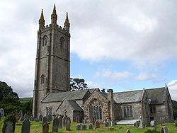
Widecombe-in-the-Moor
Contenu soumis à la licence CC-BY-SA. Source : Article Widecombe-in-the-Moor de Wikipédia en français (auteurs)
Regardez d'autres dictionnaires:
Widecombe-in-the-Moor — is a small village located within the heart of the Dartmoor National Park in Devon, England. gbmapping|SX718767. The name is thought to derive from Withy combe which means Willow Valley.According to Widecombe s official website, there are 196… … Wikipedia
Widecombe-in-the-Moor — 50.576666666667 3.8119444444444 Koordinaten: 50° 35′ N, 3° 49′ W … Deutsch Wikipedia
Widecombe Fair — takes place annually on the second Tuesday in September, attracting thousands of visitors to the tiny Dartmoor village of Widecombe in the Moor. It is well known as the subject of the folk song of the same name, featuring Uncle Tom Cobley and his … Wikipedia
The Great Thunderstorm, Widecombe — The Great Thunderstorm of Widecombe in the Moor, Dartmoor, took place on Sunday, 21 October 1638, when the church of St Pancras was apparently struck by ball lightning during a severe thunderstorm. An afternoon service was taking place at the… … Wikipedia
The Church House — is a fine two storey granite building in Widecombe in the Moor, Devon, England, dating from 1537, which stands alongside the church, overlooking the tiny village square. It is a National Trust property.OverviewThe Church House is thought to have… … Wikipedia
Widecombe — 50.576666666667 3.81194444444447Koordinaten: 50° 35′ N, 3° 49′ W … Deutsch Wikipedia
List of lost settlements in the UK — This list includes some of the thousands of deserted medieval villages (DMVs), shrunken villages and other settlements known to have been lost or significantly reduced in size over the centuries. There are estimated to be as many as 3,000 DMVs in … Wikipedia
Climate of the United Kingdom — Hardiness zones in the British Isles. The United Kingdom straddles the geographic mid latitudes between 50 60 N from the equator. It is also positioned on the western seaboard of Eurasia, the world s largest land mass. These boundary conditions… … Wikipedia
Drought in the United Kingdom — Droughts in the United Kingdom are a relatively common feature of the weather in the UK, with one around every 5–10 years on average. These droughts are usually confined to summer, when a blocking high causes hot, dry weather for an extended… … Wikipedia
Dartmoor tin-mining — The wheelpit at Huntingdon mine The Dartmoor tin mining industry is thought to have originated in pre Roman times,[1] and continued right through to the 20th century. From the 12th century onwards tin mining was regulated by a Stannary Parliament … Wikipedia

