Wasatch and Uinta Mountains
- Wasatch and Uinta Mountains
-
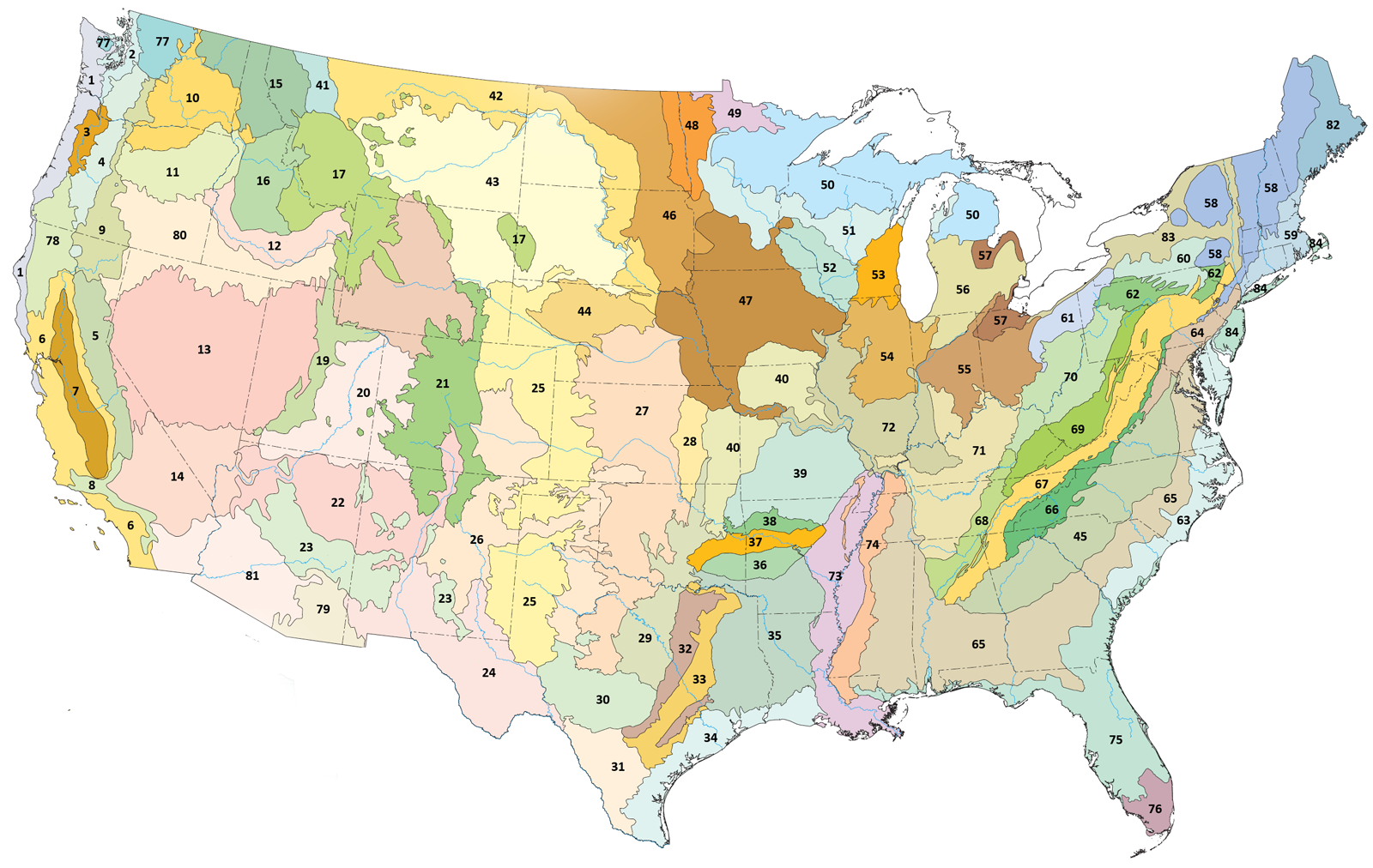
Carte des écorégions de niveau III aux États-Unis (l'écorégion est représentée par le numéro 19).
La Wasatch and Uinta Mountains est une des écorégions de niveau III utilisée par l'Agence de protection de l'environnement des États-Unis pour catégoriser les milieux naturels en Amérique du Nord.
La zone s'étend du sud de l'Utah jusque que dans les États de l'Idaho et du Wyoming au nord. L'écorégion tire son nom des monts Uinta et Wasatch qui lui donnent son caractère montagneux. L'écosystème de la région est composé de forêts de montagnes[N 1],[1],[2],[3].
Voir aussi
Notes
Références
Wikimedia Foundation.
2010.
Contenu soumis à la licence CC-BY-SA. Source : Article Wasatch and Uinta Mountains de Wikipédia en français (auteurs)
Regardez d'autres dictionnaires:
Uinta Mountains — /yooh in teuh/ a mountain range in NE Utah, part of the Rocky Mountains. Highest peak, Kings Peak, 13,498 ft. (4115 m). * * * Mountain range, south central Rocky Mountains, U.S. They extend east more than 100 mi (160 km) from the Wasatch… … Universalium
Uinta Mountains — Geobox|Range name=Uinta Mountains image caption=This view of Kings Peak and the Henry s Fork Basin shows the cliff bands and basins typical throughout the Uintas. country=United States state=Utah| state1=Colorado parent=Rocky Mountains… … Wikipedia
Uinta Mountains — p1p5 Uinta Mountains Kings Peak und Henry s Fork Basin zeigen die typische Landschaftsform in den Uinta Mountains … Deutsch Wikipedia
Wasatch National Forest — ▪ forest, United States in the Stansbury, Sheeprock, Wasatch, and Uinta mountains of Utah and Wyoming, U.S. Established in 1906, it has an area of 1,072,443 acres (434,002 hectares) in four divisions. The forest contains a portion of the… … Universalium
Montagnes Uinta — Monts Uinta Pour les articles homonymes, voir Uinta. Monts Uinta Géographie … Wikipédia en Français
Uinta National Forest — (pronEng|juːˈɪntə) is a national forest located in north central Utah, USA. It was originally part of the Uinta Forest Reserve, created by Grover Cleveland on February 2, 1897. The name is derived from the Ute word Yoov we teuh which means pine… … Wikipedia
Northern Basin and Range ecoregion — This article is about the ecoregion designated by the EPA. For the associated geographical feature, see Great Basin. Level III ecoregions in the Pacific Northwest. The Northern Basin and Range (80) borders the Sierra Nevada (5), Eastern Cascades… … Wikipedia
Monts Uinta — Pour les articles homonymes, voir Uinta. Monts Uinta Géographie Altitude … Wikipédia en Français
Central Basin and Range ecoregion — This article is about the ecoregion designated by the EPA. For the associated United States physiographic region, see Great Basin section. Central Basin and Range from space … Wikipedia
Wasatch Range — Geobox|Range name=Wasatch Range image caption=View of the Wasatch Range from the Salt Lake City Public Library country=United States state=Utah parent=Rocky Mountains highest=Mount Nebo highest elevation imperial=11928 highest lat d= | highest… … Wikipedia