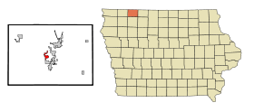
Wahpeton (Iowa)
Contenu soumis à la licence CC-BY-SA. Source : Article Wahpeton (Iowa) de Wikipédia en français (auteurs)
Regardez d'autres dictionnaires:
Wahpeton (Iowa) — Wahpeton Ciudad de los Estados Unidos … Wikipedia Español
Wahpeton, Iowa — Infobox Settlement official name = Wahpeton, Iowa settlement type = City nickname = motto = imagesize = image caption = image imagesize = image caption = image mapsize = 250px map caption = Location of Wahpeton, Iowa mapsize1 = map caption1 =… … Wikipedia
Wahpeton — is the name of 2 cities in the United States:*Wahpeton, Iowa *Wahpeton, North DakotaThe Sisseton Wahpeton Sioux Tribe is a branch of the Dakota or Sioux … Wikipedia
Wahpeton — Wahpeton, ND U.S. city in North Dakota Population (2000): 8586 Housing Units (2000): 3492 Land area (2000): 4.997368 sq. miles (12.943123 sq. km) Water area (2000): 0.000000 sq. miles (0.000000 sq. km) Total area (2000): 4.997368 sq. miles… … StarDict's U.S. Gazetteer Places
Wahpeton, IA — U.S. city in Iowa Population (2000): 462 Housing Units (2000): 732 Land area (2000): 1.279442 sq. miles (3.313740 sq. km) Water area (2000): 0.027708 sq. miles (0.071764 sq. km) Total area (2000): 1.307150 sq. miles (3.385504 sq. km) FIPS code:… … StarDict's U.S. Gazetteer Places
Wahpeton — Ehemaliges Stammesgebiet der Wahpeton, benachbarter Stämme und heutige Reservationen Die Wahpeton sind ein nordamerikanischer Indianerstamm und gehören neben den Mdewakanton, Sisseton und Wahpekute zu den Dakota aus der Sioux Sprachfamilie.… … Deutsch Wikipedia
Iowa Highway 86 — Infobox road state=IA type=IA route=86 alternate name= length mi=13 length round=0 length ref=Iowahighwaysref|lowrg=80|hirng=89|num=86|m iter=yes|access date=2008 04 18] established=February 1981 direction a=South starting terminus= junction=… … Wikipedia
Wahpeton — Cette page d’homonymie répertorie les différents sujets et articles partageant un même nom. Wahpeton Wahpeton, ville américaine de l Iowa. Wahpeton, ville américaine du Dakota du Nord. Voir aussi Sisseton Wahpeton, tribu Sioux. Catégorie … Wikipédia en Français
Sisseton-Wahpeton Oyate — Sisseton Wahpeton Pour les articles homonymes, voir Wahpeton. Localisation des tribus Sisseton Wahpeton Les tribus Sioux Sisseton Wahpeton viv … Wikipédia en Français
Dickinson County, Iowa — Location in the state of Iowa … Wikipedia
 Pour les articles homonymes, voir Wahpeton.
 États-Unis
 Iowa
Iowa