Bach (Tyrol)
- Bach (Tyrol)
-
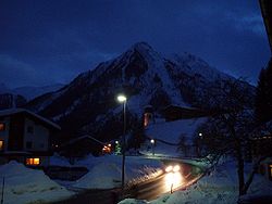
L'église de Bach et le Sonnenkogel
Bach est une commune autrichienne du Tyrol.
Géographie
Histoire
Wikimedia Foundation.
2010.
Contenu soumis à la licence CC-BY-SA. Source : Article Bach (Tyrol) de Wikipédia en français (auteurs)
Regardez d'autres dictionnaires:
Bach (Homonymie) — Cette page d’homonymie répertorie les différents sujets et articles partageant un même nom … Wikipédia en Français
Bach (homonymie) — Cette page d’homonymie répertorie les différents sujets et articles partageant un même nom. Sur les autres projets Wikimedia : « Bach », sur le Wiktionnaire (dictionnaire universel) Patronyme Pour consulter un article plus général … Wikipédia en Français
Bach, Austria — Infobox Ort in Österreich Art = Gemeinde Name = Bach Wappen = lat deg = 47 | lat min = 16 | lat sec = 00 lon deg = 10 | lon min = 24 | lon sec = 00 Bundesland = Tirol Bezirk = Reutte Höhe = 1070 Fläche = 56.9 Einwohner = 684 Stand = 2005 12 31… … Wikipedia
Ridnauner Bach — Origin Ridnauntal (South Tyrol) Mouth Eisack at Sterzing Basin countries Italy Length 25 km (16 mi) Basin area 212 km … Wikipedia
Höfen (Tyrol) — Pour les articles homonymes, voir Höfen. Höfen Blason de Höfen … Wikipédia en Français
Mühlauer Bach — also: Worm Creek Origin Arzler wind gap above Innsbruck Mouth Inn River Basin countries Austria, Tyrol Length 5 km … Wikipedia
Aldranser Bach — Geobox River name = Aldranser Bach native name = other name = other name1 = other name2 = other name3 = other name4 = other name4 = map size = map caption = country = Austria country1 = country2 = country3 = country4 = country5 = country6 =… … Wikipedia
Sistranser Bach — Infobox River river name = Sistranser Bach caption = origin = Sistrans Alp mouth = Inn River, Lanser brook basin countries = Tyrol length = 6 km elevation = 1.400 1.600 m mouth elevation = 575 m, city area of Innsbruck discharge = watershed = The … Wikipedia
Höttinger Bach — Infobox River river name = Höttinger Bach caption = origin = Umbrückler Alp above Innsbruck mouth = Inn River near Mariahilf basin countries = Austria, Tyrol length = 8.75 km elevation = 1.100 m mouth elevation = discharge = watershed = The… … Wikipedia
Österreich [3] — Österreich (Gesch.). Das heutige Erzherzogthum Ö. wurde zur Zeit der Römer auf dem linken Donauufer von Germanen, namentlich Markomannen, Quaden, Juthungen, auf dem rechten von Celten, namentlich Tauriskern u. Pannoniern, bewohnt. Das Land auf… … Pierer's Universal-Lexikon


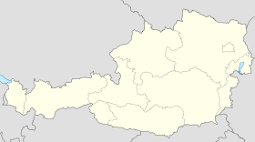
 Autriche
 Tyrol
Tyrol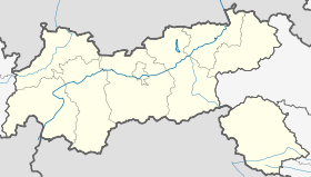

 Bach (Tyrol)


