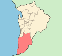
- Ville d'Onkaparinga
-
Ville d'Onkaparinga 
Localisation de la LGADonnées générales Pays  Australie
État ou Territoire Australie-Méridionale Région Adélaïde Superficie 518,4 km² Population 149 735 hab. (2006) Densité 289 hab./km² Administration Nom du Conseil Conseil de la Ville d'Onkaparinga Siège du Conseil Noarlunga Centre Maire Lorraine Rosenberg Site web http://www.onkaparinga.sa.gov.au/ modifier 
La Ville d'Onkaparinga (City of Onkaparinga) est une zone d'administration locale au sud du centre ville d'Adélaïde en Australie-Méridionale en Australie.
Quartiers
- Aberfoyle Park CP:5159
- Aldinga Code Postal:5173
- Aldinga Beach CP:5173
- Blewitt Springs CP:5171
- Chandlers Hill CP:5159
- Cherry Gardens CP:5157
- Christie Downs CP:5164
- Christies Beach CP:5165
- Clarendon CP:5157
- Coromandel East CP:5157
- Coromandel Valley CP:5051
- Darlington CP:5047
- Dorset Vale CP:5157
- Flagstaff Hill CP:5159
- Hackham CP:5163
- Hackham West CP:5163
- Happy Valley CP:5159
- Huntfield Heights CP:5163
- Ironbank CP:5153
- Kangarilla CP:5157
- Lonsdale CP:5160
- Maslin Beach CP:5170
- McLaren Flat CP:5171
- McLaren Vale CP:5171
- Moana CP:5169
- Morphett Vale CP:5162
- Noarlunga Centre CP:5168
- Noarlunga Downs CP:5168
- O'Halloran Hill CP:5158
- O'Sullivan Beach CP:5166
- Old Noarlunga CP:5168
- Old Reynella CP:5161
- Onkaparinga Hills CP:5163
- Port Noarlunga CP:5167
- Port Noarlunga South CP:5167
- Port Willunga CP:5173
- Reynella CP:5161
- Reynella East CP:5161
- Seaford CP:5169
- Seaford Heights CP:5169
- Seaford Meadows CP:5169
- Seaford Rise CP:5169
- Sellicks Beach CP:5174
- Sellicks Hill CP:5174
- Tatachilla CP:5171
- The Range, South Australia CP:5172
- Whites Valley CP:5172
- Willunga CP:5172
- Willunga South CP:5172
- Woodcroft CP:5162
Références
Wikimedia Foundation. 2010.
