Tuggeranong
- Tuggeranong
-
35° 25′ 28″ S 149° 05′ 20″ E / -35.4244, 149.0888

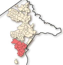
L'arrondissement de Weston Creek à Canberra.
Tuggeranong est l'arrondissement (district) le plus au sud de la ville de Canberra, la capitale fédérale de l'Australie. Il comprend 19 quartiers (suburbs), 31 819 logements et 87 119 habitants. Il a une superficie de 117 km² et se trouve à l'est de la Murrumbidgee.
Le nom de la ville est d'origine aborigène et signifie froide plaine.
Des peintures et autres traces trouvées dans la région montrent que l'endroit était habité depuis plus de 21 000 ans.

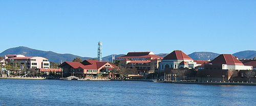
Le centre ville et le lac Tuggeranong.
Voir aussi
Wikimedia Foundation.
2010.
Contenu soumis à la licence CC-BY-SA. Source : Article Tuggeranong de Wikipédia en français (auteurs)
Regardez d'autres dictionnaires:
Tuggeranong — is the southernmost town centre of Canberra, the capital city of Australia. It comprises 19 suburbs with a total of 31,819 dwellings, housing 87,119 people of the 324,034 people in the Australian Capital Territory (2006 Census). The district… … Wikipedia
Tuggeranong — Lage von Tuggeranong Tuggeranong ist ein Stadtbezirk von Canberra, der Hauptstadt Australiens. Er ist 159,9 km² groß, umfasst 19 Stadtteile mit insgesamt 90.410 Einwohnern (2003) und liegt am Murrumbidgee River in einem Tal der Brindabella Ranges … Deutsch Wikipedia
Tuggeranong Arts Centre — is a purpose built centre located on the shores of Lake Tuggeranong, in the south of Canberra, Australian Capital Territory. It is a dynamic organization providing a wide range of arts activities for community participation, development and… … Wikipedia
Tuggeranong Hyperdome — Location Tuggeranong, Australian Capital Territory, Australia Opening date 1987 Management Colonial Fir … Wikipedia
Tuggeranong Hill — viewed from Box Hill Avenue in Conder. Tuggeranong Hill is located in Tuggeranong, Canberra. It is sometimes referred to as Mount Tuggeranong due to its prominence. Lanyon Valley is almost completely surrounded by hills and mountains and… … Wikipedia
Tuggeranong Homestead — is located in the Australian Capital Territory in the area now covered by the suburb of Richardson. The first authorised landowner of the Tuggeranong area following white settlement was Peter Murdoch, aide de camp of Thomas Brisbane, who was… … Wikipedia
Tuggeranong Town Centre — services the southernmost Canberra district of Tuggeranong. It is located on the south western side of Lake Tuggeranong and composed of a large three storey mall, the Tuggeranong Hyperdome, as well as a smaller shopping complex, the Homeworld,… … Wikipedia
Tuggeranong Uniting Church — is part of the Uniting Church in Australia, and is located in the Tuggeranong Valley. It has a variety of worship styles contemporary, traditional, and youth focused; an active prayer life; a specific focus on small group involvement; and a… … Wikipedia
Tuggeranong Parkway — La Tuggeranong Parkway est l une des principales voies autoroutières de Canberra, en Australie. Souvent appelée « The Parkway » par les habitants de la ville, elle relie le quartier de Civic au nord à l arrondissement de Tuggeranong, en … Wikipédia en Français
Tuggeranong United — Infobox Football club clubname = Tuggeranong United fullname = Tuggeranong United Football Club nickname = Tuggies shortname = founded = 1986 dissolved = ground = Kambah 2 Oval, Kambah, ACT capacity = chairman = mgrtitle = manager = league = ACT… … Wikipedia


