Tenafly (New Jersey)
- Tenafly (New Jersey)
-

Pour les articles homonymes, voir
Tenafly.
40° 55′ 20″ N 73° 57′ 50″ W / 40.922222, -73.963889
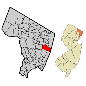
Tenafly est une localité (borough, une banlieue) du comté de Bergen dans le New Jersey.
La population de la ville s'élevait à 13.806 habitants en 2000.
Les premiers occupants européens à Tenafly furent des Néerlandais à la fin du dix-septième siècle. Le nom « Tenafly » provient de l'expression néerlandaise « Tiene Vly » ou « dix marais », nom donné par les colons néerlandais en 1688.
Éducation
À Tenafly se situe la Tenafly High School.
Personnalités liées à la commune
- William Beutenmüller (1864-1934), entomologiste américain : décès,
- Zach Braff, acteur et réalisateur : tournage du film Garden State dans les paysages de la ville,
- Hope Davis, diplômée de la Tenafly High School,
- Tate Donovan (1963-), acteur : naissance,
- Léon M. Goldensohn (1911-1961), psychiatre au procès de Nuremberg qui y vécut de 1950 à sa mort,
- Ed Harris (1950-), acteur : naissance,
- Mira Sorvino (1967-), productrice : naissance
- Lea Michele (1986-), actrice et chanteuse
Wikimedia Foundation.
2010.
Contenu soumis à la licence CC-BY-SA. Source : Article Tenafly (New Jersey) de Wikipédia en français (auteurs)
Regardez d'autres dictionnaires:
Tenafly, New Jersey — Tenafly (New Jersey) Pour les articles homonymes, voir Tenafly. Tenafly Pays … Wikipédia en Français
Tenafly, New Jersey — Infobox Settlement official name = Tenafly, New Jersey settlement type = Borough nickname = motto = imagesize = image caption = image imagesize = image caption = image mapsize = 250x200px map caption = Map highlighting Tenafly s location within… … Wikipedia
Elizabeth Cady Stanton House (Tenafly, New Jersey) — Infobox nrhp | name =Elizabeth Cady Stanton House nrhp type = nhl caption = location= 135 Highwood Avenue, Tenafly, New Jersey lat degrees = 40 lat minutes = 55 lat seconds = 32.9 lat direction = N long degrees = 73 long minutes = 57 long seconds … Wikipedia
New Jersey locations by per capita income — New Jersey is one of the wealthiest states in the United States of America, with a per capita income of $27,006 (2000) and a personal per capita income of $40,427 (2003). Its median household income is $55,146 (2000), ranked first in the country … Wikipedia
New Jersey Legislative Districts, 2001 apportionment — New Jersey Legislature 210th through 214th Legislatures Type Type … Wikipedia
New Jersey Transit — (NJT) provides bus service throughout New Jersey, commuter rail service in North and Central Jersey and along the Route 30 corri … Wikipedia
New Jersey's congressional districts — New Jersey s 13 congressional districts, shaded according to representative party. In the 2010 elections, Republican Jon Runyan picked up the 3rd district from Democrat John Adler, who had held the seat for two years. There are currently thirteen … Wikipedia
New Milford High School (New Jersey) — New Milford High School Knight Location One Snyder Circle … Wikipedia
New Jersey Legislative Districts, 2011 apportionment — New Jersey Legislature 215th through 219th Legislatures Type Type … Wikipedia
New Jersey Route 18N — Route 18N Route information Existed: 1923 – 1929 Major junctions South end … Wikipedia
 États-Unis
 New Jersey