Temburong
- Temburong
-
4°35′N 115°10′E / 4.583, 115.167
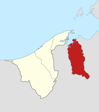
Temburong est le district ou daerah le plus oriental du Sultanat de Brunei. Il doit son nom à la rivière Sungai Temburong, principal cours d’eau le traversant. La frontière orientale du district est constituée par la rivière Sungai Pandaruan. Son chef-lieu est la ville de Bangar.
Il présente la particularité de constituer une enclave et d'être séparé du reste de Brunei par la Malaisie. Le territoire est cependant accessible par la mer en traversant la Baie de Brunei.
Provinces
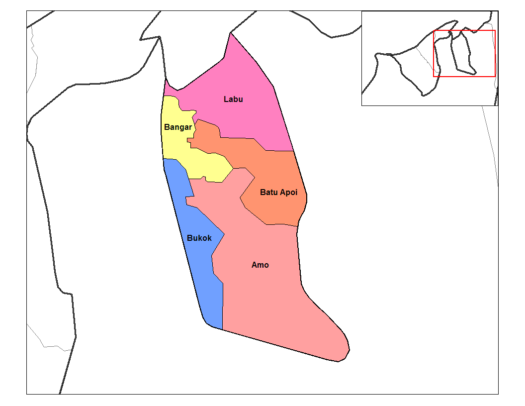
Le district est composé de 5 mukims (provinces) :
- Amo
- Bangar
- Batu Apoi
- Bukok
- Labu
Biodiversité
25 hectares de la région de Kuala Belalong ont été alloués à des projets conjoints de recherche à risque menées par l'Université Brunei Darussalam, Kuala Belalong field study centre et CTFS. Il est appelé le "Belalong Rainforest Experience», et est financé par la Hongkong and Shanghai Banking Corporation. Brunei[1].
Éducation
Cette section est vide, insuffisamment détaillée ou incomplète.
Votre aide est la bienvenue !
Santé
Cette section est vide, insuffisamment détaillée ou incomplète.
Votre aide est la bienvenue !
Références
Articles connexes
Wikimedia Foundation.
2010.
Contenu soumis à la licence CC-BY-SA. Source : Article Temburong de Wikipédia en français (auteurs)
Regardez d'autres dictionnaires:
Temburong — Distrito de Temburong Mapa Datos básicos País Brunéi … Wikipedia Español
Temburong — Der Begriff Temburong steht für: einen Distrikt in Brunei, siehe Temburong (Distrikt) einen Fluss in Brunei, siehe Temburong (Fluss) Diese Seite ist eine Begriffsklärung zur Unterscheidung mehrerer mit demselben Wort bezeichneter Begriffe … Deutsch Wikipedia
Temburong — Admin ASC 1 Code Orig. name Temburong Country and Admin Code BN.03 BN … World countries Adminstrative division ASC I-II
Temburong District — Temburong is the eastern most district ( daerah ) in Brunei. It is an exclave, as it is separated from the rest of Brunei by Malaysia and Brunei Bay. Its capital is Bangar. The main town located in the district is Pekan Bangar.The district… … Wikipedia
Temburong (Distrikt) — Karte Bruneis mit den Temburong Distrikt (koloriert) … Deutsch Wikipedia
Brunei Bay — (Malay: Teluk Brunei) is the gateway to Brunei and Borneo. It is located 4°45 5°02 N, 114°58 115°10 E; east of Bandar Seri Begawan. The Brunei portion of the bay is in two sections separated by a finger of Sarawak (Limbang) about 6km wide at the… … Wikipedia
BN-TE — Karte Bruneis mit den Temburong Distrikt (koloriert) Temburong ist der am östlichsten gelegene Distrikt (daerah) Bruneis mit 9.300 Einwohnern auf einer Fläche von 1.166 km². Der Distrikt wird durch die Bucht von Brunei im Norden und Malaysia im… … Deutsch Wikipedia
Brunei — State of Brunei, the Abode of Peace Negara Brunei Darussalam نڬارا بروني دارالسلام … Wikipedia
Mukim Bangar, Brunei — Bangar Mukim Mukim location … Wikipedia
Brunei-Malaysia border — The border between Brunei and Malaysia consist of a 481.3km land border and substantial lengths of maritime borders stretching to the edge of the continental shelf in the South China Sea. Except for its South China Sea coastline, Brunei is… … Wikipedia
 Brunei
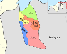 Mukims de Temburong