Taysan (Batangas)
- Taysan (Batangas)
-
Taysan
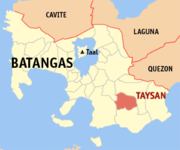
Carte de Batangas avec localisation de Taysan
Taysan est une municipalité de la province de Batangas.
 Portail de la géographie
 Portail des Philippines
Catégories : Wikipédia:ébauche ville des Philippines | Municipalité de la province de Batangas
Wikimedia Foundation.
2010.
Contenu soumis à la licence CC-BY-SA. Source : Article Taysan (Batangas) de Wikipédia en français (auteurs)
Regardez d'autres dictionnaires:
Taysan, Batangas — Taysan is a 4th class municipality in the province of Batangas, Philippines. According to the 2000 census, it has a population of 29,836 people in 5,823 households.BarangaysTaysan is politically subdivided into 20 barangays. * Bacao * Bilogo *… … Wikipedia
Taysan — Municipality of Taysan Lage von Taysan in der Provinz Batangas Basisdaten Bezirk: CAL … Deutsch Wikipedia
Taysan — 13° 44′ 31″ N 121° 13′ 23″ E / 13.74194444, 121.22305556 … Wikipédia en Français
Batangas — 13° 50′ 00″ N 121° 00′ 00″ E / 13.8333, 121 … Wikipédia en Français
Legislative districts of Batangas — Philippines This article is part of the series: Politics and government of the Philippines … Wikipedia
Tanauan, Batangas — City of Tanauan Lungsod ng Tanauan Component City Nickname(s): Cradle of the Noble Heroes … Wikipedia
Malvar, Batangas — For the Spanish wine grape, see Malvar (grape). Municipality of Malvar Bayan ng Malvar Municipality … Wikipedia
Nasugbu, Batangas — Nasugbu Municipality Map of Batangas showing the location of Nasugbu … Wikipedia
Rosario, Batangas — Rosario Municipality Map of Batangas showing the location of Rosario … Wikipedia
Cuenca, Batangas — Cuenca Bayan ng Cuenca Munisipalidad ng Cuenca pueblo de Cuenca Municipality Nickname(s): Home of the Bakers … Wikipedia

