St Teath
- St Teath
-
50° 35′ 34″ N 4° 44′ 10″ W / 50.5929, -4.7362

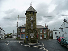
La tour au village de St Teath
St Teath est un village de Cornouailles du Nord près de Delabole et Camelford. L'église médiévale a pour patronne Saint-Tetha.
Wikimedia Foundation.
2010.
Contenu soumis à la licence CC-BY-SA. Source : Article St Teath de Wikipédia en français (auteurs)
Regardez d'autres dictionnaires:
teath — var. tathe; obs. f. tithe … Useful english dictionary
St Teath — (pronEng|ˌsɪntˈtɛθ) is a small village in North Cornwall, England, United Kingdom. The village church is also the parish church. Other villages in the parish of St. Teath include; Delabole, Treligga, Trewalder and Newhall Green.Saint Tethe was… … Wikipedia
Callander — CALLANDER, a parish, in the county of Perth; containing, with the village of Kilmahog, 1665 inhabitants, of whom 1107 are in the village of Callander, 6 miles (N. N. E.) from Port of Monteith. This place derives its name, of Gaelic origin,… … A Topographical dictionary of Scotland
Diocese of Truro — Location Ecclesiastical province Canterbury Archdeaconries Bodmin, Cornwall Coordinates … Wikipedia
North Cornwall — For the UK Parliament constituency, see North Cornwall (UK Parliament constituency). North Cornwall District Geography Status District HQ … Wikipedia
Delabole — Coordinates: 50°37′19″N 4°43′59″W / 50.622°N 4.733°W / 50.622; 4.733 … Wikipedia
Duchy League — Countries England Founded 1965 Divisions 6 Number of teams 77 Levels on pyramid 14 19 … Wikipedia
Michaelstow — Coordinates: 50°34′40″N 4°42′48″W / 50.57789°N 4.71325°W / 50.57789; 4.71325 … Wikipedia
Moses Pitt — (c. 1639–1697) was a bookseller and printer known for the production of his Atlas of the world, a project supported by the Royal Society, and in particular by Christopher Wren.[1] He is also known as the author of The Cry of the Oppressed (1691) … Wikipedia
Брихан из Брекнока — Брихан ап Анлах валл. Brychan ap Anllach Король Брихейниога ок. 450� … Википедия

