Sideling Hill

Sideling Hill
Sideling Hill
Illustration sous licence libre bienvenue !
Géographie
Altitude 616 m
Massif Appalaches Ridge-and-valley (Appalaches)
Coordonnées 39° 43′ 09″ Nord
       78° 17′ 01″ Ouest
/ 39.71917, -78.28361
39°43′09″N 78°17′01″O / 39.71917, -78.28361
Administration
Pays Drapeau des États-Unis États-Unis
États Virginie-Occidentale
Maryland
Pennsylvanie
Comtés Hampshire, Morgan
Washington
Fulton

Géolocalisation sur la carte : Pennsylvanie

(Voir situation sur carte : Pennsylvanie)
Sideling Hill

Géolocalisation sur la carte : Maryland

(Voir situation sur carte : Maryland)
Sideling Hill

Géolocalisation sur la carte : Virginie-Occidentale

(Voir situation sur carte : Virginie-Occidentale)
Sideling Hill

Géolocalisation sur la carte : États-Unis

(Voir situation sur carte : États-Unis)
Sideling Hill

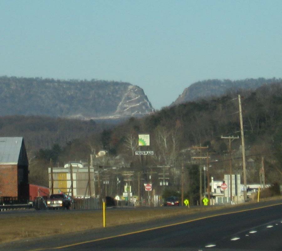
Sideling Hill fait partie du plateau des Alleghenys des Appalaches (faisant aussi partie du Appalaches Ridge-and-valley). Elle traverse la Virginie-Occidentale, le Maryland et la Pennsylvanie et atteint son point le plus haut à 616 m dans le comté de Fulton (Pennsylvanie).

Passage de la route

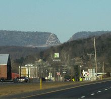
Le passage de l'Interstate 68 à travers la Sideling Hill

Le passage de la route Interstate 68 est profond de 103,6 mètres et traverse la Sideling Hill, à environ 9,6 km à l'ouest de Hancock dans le comté de Washington. Il est considéré comme un impressionnant passage de montagne fait de la main de l'homme, visible de nombreux kilomètres à la ronde et est l'une des zones où la roche est la plus exposée du Maryland et dans tout le nord-est des États-Unis. Presque 249,8 mètres de strates sont exposés dans ce passage. Bien que d'autres expositions de strates puissent surpasser la Sideling Hill en ce qui concerne l'épaisseur des strates exposées ou de la qualité de la structure géologique, peu peuvent égaler sa combinaison des deux.

Il y a un centre d'exposition qui fut installer de sorte à initier le public à ce qu'est la géologie du passage. Un pont piétonnier traverse l'Intersate 68 pour un meilleur accès à la paroi, en complément à une zone de pique-nique.

Références


Wikimedia Foundation. 2010.

Contenu soumis à la licence CC-BY-SA. Source : Article Sideling Hill de Wikipédia en français (auteurs)

Игры ⚽ Нужно сделать НИР?

Regardez d'autres dictionnaires:

  • Sideling Hill — Infobox Mountain Name = Sideling Hill Photo = SidelingHill I 68.jpg Caption = Sideling Hill road cut one of the best rock exposures in Maryland and indeed in the entire northeastern United States. R.D. Conkwright… …   Wikipedia

  • Sideling Hill Tunnel — is one of three original Pennsylvania Turnpike tunnels which were abandoned (this one in 1968) after two massive realignment projects. The others included the nearby Rays Hill Tunnel, and further west, the Laurel Hill Tunnel. The reason for… …   Wikipedia

  • Sideling Hill Creek (Potomac River) — Sideling Hill Creek is a tributary stream of the Potomac River in the U.S. states of Maryland and Pennsylvania. Sideling Hill Creek flows southward along the western flanks of Sideling Hill, from which the stream takes its name. It forms the… …   Wikipedia

  • Sideling Hill Creek — may refer to:*Sideling Hill Creek (Aughwick Creek) *Sideling Hill Creek (Potomac River) …   Wikipedia

  • Sideling Hill Creek (Aughwick Creek) — Sideling Hill Creek is a tributary of Aughwick Creek in Huntingdon County, Pennsylvania in the United States.Sideling Hill Creek joins Aughwick Creek near the community of Maddensville.ee also*List of rivers in PennsylvaniaReferences*Gertler,… …   Wikipedia

  • Sideling (disambiguation) — Sideling may refer to:*Sideling, a geologic featureIn the United States: *Sideling Hill, part of the Allegheny Mountains *Sideling Hill Creek (Aughwick Creek), a tributary of Aughwick Creek *Sideling Hill Creek (Potomac River) , a tributary of… …   Wikipedia

  • Laurel Hill Tunnel — is one of three original Pennsylvania Turnpike tunnels which were abandoned (this one in 1964) after two massive realignment projects. The Laurel Hill Tunnel was bored under the border between Westmoreland and Somerset Counties. The others,… …   Wikipedia

  • Rays Hill Tunnel — Ray s Hill Tunnel is one of three original Pennsylvania Turnpike tunnels which were abandoned (this one in 1968) after two massive realignment projects. The others included the Sideling Hill Tunnel, and further west, the Laurel Hill Tunnel. The… …   Wikipedia

  • Martin Hill — For the hill in Antarctica, see Martin Hill (Antarctica). Martin Hill Martin Hill Elevation …   Wikipedia

  • Oxon Cove Park and Oxon Hill Farm — IUCN Category V (Protected Landscape/Seascape) …   Wikipedia

Share the article and excerpts

Direct link
Do a right-click on the link above
and select “Copy Link”