Sibuyan
- Sibuyan
-
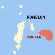
Sibuyan est une île de l'archipel des Philippines. En 2000, il y avait 52 615 habitants pour une superficie de 445 km². Sa particularité est son point culminant, situé à 2 050 m d'altitude (Mt Guiting-guiting). C'est une ile très sauvage, et certaines espèces végétales y sont endémiques.
Elle est située dans la province de Romblon et est divisée en trois municipalités (Cajidiocan, Magdiwang et San Fernando).

L'
île de Sibuyan (
rouge)
dans la province de Romblon
Wikimedia Foundation.
2010.
Contenu soumis à la licence CC-BY-SA. Source : Article Sibuyan de Wikipédia en français (auteurs)
Regardez d'autres dictionnaires:
Sibuyan — Sibuyan, Insel, zur Gruppe der Bissayer (s.d. d) gehörig … Pierer's Universal-Lexikon
Sibuyan — Vorlage:Infobox Insel/Wartung/Bild fehlt Sibuyan Gewässer Sibuyan See Inselgruppe Philippinen Geographische Lage … Deutsch Wikipedia
Sibuyan Island — Infobox Islands name = Sibuyan image caption = Map of the Romblon showing the location of the municiplaity of San Fernando on the island. locator Location map|Philippines|lat=12.433333|long=122.55|width=175|float=center map custom = yes native… … Wikipedia
Sibuyan-See — Die Sibuyan See ist ein zentral zwischen den philippinischen Inseln im Bezirk MIMARO gelegenes Binnenmeer. Sie wird manchmal auch Sibu See abgekürzt. Die mittleren Philippinen mit der Sibuyan See … Deutsch Wikipedia
Sibuyan Sea — The Sibuyan Sea is a small sea in the Philippines that separates the Visayas from the northern Philippine island of Luzon. It is bounded by the island of Panay to the south, Mindoro to the west, and to the north the Bicol Peninsula of Luzon… … Wikipedia
Sibuyan Sea — geographical name body of water central Philippines bounded by Mindoro, S Luzon, & the Visayan Islands … New Collegiate Dictionary
Mar de Sibuyan — (Sibuyan Sea) Bahia de Romblón, en la isla homónima Ubicación geográfica … Wikipedia Español
Mer de Sibuyan — Carte de la mer de Sibuyan. Géographie humaine Pays côtier(s) … Wikipédia en Français
Mer De Sibuyan — La mer de Sibuyan au centre de la carte Type Mer intérieure Localisation Océan Pacifique Pays côtier(s) … Wikipédia en Français
Mer de sibuyan — La mer de Sibuyan au centre de la carte Type Mer intérieure Localisation Océan Pacifique Pays côtier(s) … Wikipédia en Français
 Philippines

