Shebelle

Shebelle

Chébéli

Chébéli
Shabeelle NASA.jpg

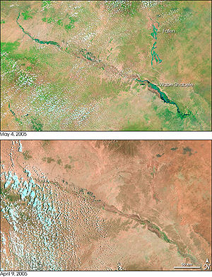
Caractéristiques
Longueur 1 130 km
Bassin  ?
Débit moyen 73 m3⋅s-1 (frontière entre l'Éthiopie et la Somalie)
Cours
Source Plateaux d'Éthiopie
Géographie
Pays traversés Éthiopie Éthiopie, Somalie Somalie

Le Chébéli ou Shabele est un cours d'eau de la Corne de l'Afrique qui traverse les territoires de l'Éthiopie et de la Somalie.

Sommaire

Description

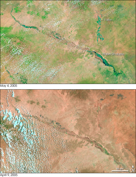
Long de 1 130 km, il prend sa source sur les Plateaux d'Éthiopie et se dirige vers le sud-est vers la Somalie, jusqu'à Mogadiscio. Juste avant Mogadiscio, il se coude en direction du sud-ouest et suit alors la côte.

Après Mogadiscio, le Chébéli devient saisonnier ; la plupart du temps, le cours d'eau s'assèche avant d'atteindre l'embouchure de la Jubba, mais il lui arrive de l'atteindre réellement lors de saisons fortement pluvieuses.

Débit

D'après AQUASTAT, le débit moyen du Chébéli est de 73 mètres cubes par seconde au niveau de la frontière entre l'Éthiopie et la Somalie (c'est-à-dire 2,3 kilomètres cubes par an) [1].

Étymologie

Le nom de la rivière dérive du somali Wabi Shabeelle signifiant « rivière léopard/tigre ».

Affluents

Le Chébéli possède plusieurs affluents, saisonniers ou permanents. Ils comprennent :

  • Erer
  • Galetti
  • Wabe

Le Fafen n'atteint le Chébéli que lors d'inondations. En temps normal, il s'assèche auparavant.

Notes et références

  • Portail de l’eau Portail de l’eau
  • Portail de l'Éthiopie Portail de l'Éthiopie
  • Portail de l’Afrique Portail de l’Afrique
Ce document provient de « Ch%C3%A9b%C3%A9li ».

Wikimedia Foundation. 2010.

Contenu soumis à la licence CC-BY-SA. Source : Article Shebelle de Wikipédia en français (auteurs)

Игры ⚽ Нужен реферат?

Regardez d'autres dictionnaires:

  • Shebelle River — Infobox River river name = Shebelle River image size = caption = origin = near coord|7.2201|39.4665|display=inline|region:ET type:river mouth = Dries up near coord|0.1659|42.7727|display=inline,title|region:SO type:river, occasionally continues… …   Wikipedia

  • Shebelle Valley — The Shebelle Valley or Shabeelle Valley is a valley in the Horn of Africa.It follows the line of the Shebelle River north from the Indian Ocean through Somalia and into Ethiopia.Along with the Jubba Valley, and nearby lakes Chamo and Abaya, the… …   Wikipedia

  • Shebelle — Vorlage:Infobox Fluss/DGWK fehltVorlage:Infobox Fluss/QUELLHÖHE fehltKoordinaten fehlen! Hilf mit.Vorlage:Infobox Fluss/MÜNDUNGSHÖHE fehltVorlage:Infobox Fluss/HÖHENUNTERSCHIED fehltVorlage:Infobox Fluss/EINZUGSGEBIET fehltVorlage:Infobox… …   Deutsch Wikipedia

  • Río Shebelle — Saltar a navegación, búsqueda Río Shebelle Mapa de Somalia, con el río Shebelle y el Juba País que atraviesa Etiopía Somalia Longitud …   Wikipedia Español

  • Holland Shebelle — Holland Car Bild nicht vorhanden Holland Shebelle Hersteller: Holland Car PLC Produktionszeitraum: seit 2010 Klasse: Mittelklasse Karosser …   Deutsch Wikipedia

  • Middle Shebelle — Shabeellaha Dhexe   Region   Location in Somalia …   Wikipedia

  • Mogadishu-Villabruzzi Railway — Ansaldo 442 steam locomotive, built in 1938 and similar to those used in the Somali railway The Mogadiscio Villabruzzi Railway (Italian: Ferrovia Mogadiscio Villabruzzi) was the railway of Italian Somaliland, and connected the capital of Somalia… …   Wikipedia

  • Mogadishu — For other uses, see Mogadishu (disambiguation). Mogadishu مقديشو Maqadīshū Nickname(s): Xamar,[ …   Wikipedia

  • Geography of Ethiopia — Map of Ethiopia. Satellite image of Ethiopi …   Wikipedia

  • Kelafo — Infobox Settlement official name = Kelafo other name = Au Calif native name = nickname = settlement type = motto = imagesize = image caption = flag size = image seal size = image shield = shield size = city logo = citylogo size = mapsize = map… …   Wikipedia

Share the article and excerpts

Direct link
Do a right-click on the link above
and select “Copy Link”