Scioto River
- Scioto River
-
Scioto
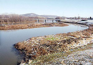
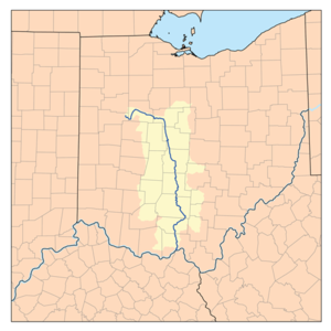
La Scioto ((en) Scioto River) est une rivière des États-Unis, l'État de l'Ohio, longue de 372 kilomètres, et un affluent de l'Ohio, donc un sous-affluent du Mississippi.
Parcours
La rivière Scioto prend sa source dans le comté d'Auglaize au centre-ouest de l'Ohio puis s'écoule généralement vers le sud en traversant la ville de Columbus où elle reçoit les eaux de son principal affluent, la rivière Olentanguy, et finalement se jette dans la rivière Ohio au niveau de Portsmouth.
Économie
La vallée de la rivière Scioto est très large comparée à la taille de la rivière et est une zone d'agriculture extensive où la terre est fertile grâce aux dépots des anciens glaciers présents lors de la dernière glaciation.
Deux barrages sont construits sur la rivière et pemettent de créer des lacs artificiels utilisés pour l'alimentation en eau potable de la ville de Columbus.
Liens externes
Notes et références
 Portail de l’eau
 Portail des États-Unis
Catégories : Cours d'eau de l'Ohio | Système hydrologique du Mississippi
Wikimedia Foundation.
2010.
Contenu soumis à la licence CC-BY-SA. Source : Article Scioto River de Wikipédia en français (auteurs)
Regardez d'autres dictionnaires:
Scioto River — Einzugsgebiet des Scioto Rivers Daten Gewässe … Deutsch Wikipedia
Scioto River — Infobox River river name = Scioto River caption = The Scioto River at Chillicothe origin = Near New Hampshire, Ohio mouth = Ohio River near Portsmouth basin countries = length = 231 miles (372 km) elevation = mouth elevation = 485 ft (148 m)… … Wikipedia
Scioto River — ▪ river, United States river rising in Auglaize county, west central Ohio, U.S., and flowing southeast past Columbus, Circleville, and Chillicothe, joining the Ohio River at Portsmouth after a course of some 230 miles (370 km). Griggs… … Universalium
Little Scioto River (Ohio River) — Little Scioto River Der Little Scioto River in der Nähe seiner Mündung in den Ohio River bei Sciotoville.Vorlage:Infobox Fluss/KARTE fehlt … Deutsch Wikipedia
Congress Lands East of Scioto River — The Congress Lands East of the Scioto River The Congress Lands East of Scioto River was a land tract in southern Ohio that was established by the Congress late in the 18th century. It is located south of the United States Military District and… … Wikipedia
Little Scioto River (Ohio River) — Infobox River river name = Little Scioto River caption = Near its confluence with the Ohio River at Sciotoville origin = mouth = basin countries = length = 40 mi (65 km) elevation = mouth elevation = ft ( m) discharge = watershed = 233 mi² (603… … Wikipedia
Big Walnut Creek (Scioto River) — Big Walnut Creek Karte des Big Walnut Creeks im Einzugsbereich des Scioto Rivers. Daten … Deutsch Wikipedia
Little Scioto River (Scioto River) — The Little Scioto River is a tributary of the Scioto River, 27.2 mi (43.8 km) long, in central Ohio in the United States. Via the Scioto and Ohio Rivers, it is part of the watershed of the Mississippi River, draining an area of 111 mi² (287 km²)… … Wikipedia
Little Scioto River — bezeichnet mehrere Flüsse in den Vereinigten Staaten: Little Scioto River (Ohio River), Nebenfluss des Ohio River im US Staat Ohio Little Scioto River (Scioto River), Nebenfluss des Scioto River im US Staat Ohio Ohio Brush Creek war historisch… … Deutsch Wikipedia
Little Scioto River — may refer to any of several streams in the state of Ohio in the United States:*Little Scioto River, a tributary of the Ohio River. *Little Scioto River, a tributary of the Scioto River. *Ohio Brush Creek was known historically as the Little… … Wikipedia
 Ohio,
Ohio, États-Unis

