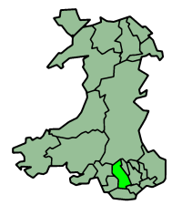
Rhondda Cynon Taff
- Rhondda Cynon Taff
-
Rhondda Cynon Taf
Rhondda Cynon Taf (Rhondda Cynon Taff en Anglais), est un des comtés du pays de Galles, créé en 1996.
Le nom est celui des trois rivières: Cynon, Rhondda et Taf.
Les villes principales du comté sont: Aberdâr, Aberpennar et Pontypridd.
 Portail du Royaume-Uni
Catégorie : Géographie du Pays de Galles
Wikimedia Foundation.
2010.
Contenu soumis à la licence CC-BY-SA. Source : Article Rhondda Cynon Taff de Wikipédia en français (auteurs)
Regardez d'autres dictionnaires:
Rhondda Cynon Taff — Saltar a navegación, búsqueda Condado de Rhondda Cynon Taff Geografía Area Total % Water En 13 lugar 424 km² ? % Sede administrativa … Wikipedia Español
Rhondda Cynon Taff — Rhondda Cynon Taff, or RCT, ( cy. Rhondda Cynon Taf) is a county borough in the preserved county of Mid Glamorgan, Wales.The county borough borders Merthyr Tydfil and Caerphilly to the east, Cardiff and the Vale of Glamorgan to the south,… … Wikipedia
Rhondda Cynon Taff — County Borough Verwaltungssitz Tonypandy Fläche 424 km² Einwohner (2006) 233.900 … Deutsch Wikipedia
Rhondda Cynon Taff — [ rɔndə sɪnən tæf], Verwaltungsdistrikt in Wales, 424 km2, 239 900 Einwohner, Verwaltungssitz ist Clydach Vale … Universal-Lexikon
Rhondda Cynon Taff — ▪ county borough, Wales, United Kingdom county borough in southern Wales. It encompasses the northwest southeast trending upper valleys of the Rivers Ely, Rhondda, Taff, and Cynon and the wooded hills between them. These hills increase in… … Universalium
Rhondda Cynon Taff — Sp Rònda Kãnonas Tãfas Ap Rhondda Cynon Taff angliškai, vališkai L Velso grafystė, D. Britanija … Pasaulio vietovardžiai. Internetinė duomenų bazė
Rhondda Cynon Taff — Admin ASC 2 Code Orig. name Rhondda Cynon Taff Country and Admin Code GB.WLS.Y9 GB … World countries Adminstrative division ASC I-II
Williamstown, Rhondda Cynon Taff — infobox UK place latitude =51.606989 longitude = 3.441819 population= country = Wales static static image caption= welsh name= constituency welsh assembly= Rhondda map type= official name= Williamstown unitary wales= Rhondda Cynon Taff… … Wikipedia
Ferndale, Rhondda Cynon Taff — infobox UK place country = Wales welsh name= Glynrhedynog constituency welsh assembly= Rhondda map type= official name= Ferndale latitude= 51.657654 longitude= 3.445885 population= 4419 [ [http://neighbourhood.statistics.gov.uk/dissemination/LeadK… … Wikipedia
Mountain Ash, Rhondda Cynon Taff — Mountain Ash ( cy. Aberpennar) is a town in the county borough of Rhondda Cynon Taff, and within the historic county boundaries of Glamorgan, Wales. It lies in the Cynon Valley.Mountain Ash hosted the National Eisteddfod in both 1905 and 1946.The … Wikipedia

