Rangitikei

Rangitikei

39° 06′ 50″ S 176° 00′ 50″ E / -39.113893, 176.013751

Page d'aide sur l'homonymie Pour les articles homonymes, voir District de Rangitikei.
Rangitikei River
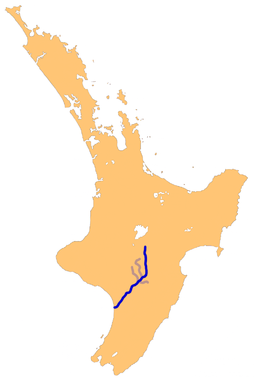
Le Taieri et ses affluents sur une carte de l'île du Sud.
Caractéristiques
Longueur 185 km
Bassin  ?
Débit moyen  ?
Cours
Se jette dans Mer de Tasman
Géographie
Pays traversés Nouvelle-Zélande
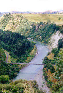
Le Rangitikei près de Bulls

Le Rangitikei est le cinquième plus long cours d'eau de la Nouvelle-Zélande. Coulant dans la région de Manawatu-Wanganui de l'île du Nord, il est long de 185 km.

Il puise sa source au sud-est du lac Taupo dans les monts Kaimanawa et son embouchure est située sur la mer de Tasman à 40 km au sud-est de la ville de Wanganui. Il coule dans le plateau central de l'île du Nord, passant par les villes de Taihape, Mangaweka, Hunterville, Marton et Bulls jusqu'à son embouchure au South Taranaki Bight à Tangimoana.

Le fleuve tire son nom du district de Rangitikei, dans lequel il coule.

Son terrain accidenté fait de lui une destination touristique, principalement pour le saut à l'élastique et le rafting. Une partie du Rangitikei fut utilisé en tant que lieu de tournage du film La Communauté de l'anneau du réalisateur néo-zélandais Peter Jackson ; il incarne une partie du grand fleuve Anduin.

Source

Sur les autres projets Wikimedia :

Notes et références


Wikimedia Foundation. 2010.

Contenu soumis à la licence CC-BY-SA. Source : Article Rangitikei de Wikipédia en français (auteurs)

Игры ⚽ Поможем написать курсовую

Regardez d'autres dictionnaires:

  • Rangitikei — is a region in New Zealand that follows the course of State Highway 1, from just south of Waiouru with the QEII Army Memorial Museum, through Taihape, Mangaweka, Hunterville, Marton and Bulls, and then winds down a minor road to the coast at… …   Wikipedia

  • Rangitikei River — Lage des Rangitikei River auf der Nordinsel Neuseelands Daten …   Deutsch Wikipedia

  • Rangitikei (New Zealand electorate) — Rangitīkei (before 2008 styled as Rangitikei without a macron) is a New Zealand Parliamentary electorate, returning one Member of Parliament to the New Zealand House of Representatives. The current MP for Rangitīkei is Simon Power of the National …   Wikipedia

  • Rangitikei-Distrikt — Rangitikei District Council Karte Basisdaten Regionen …   Deutsch Wikipedia

  • Rangitikei District — The Rangitikei District is a Territorial Authority located primarily in the Manawatu Wanganui region in the North Island of New Zealand, although a small part, the town of Ngamatea (13.63% by land area), of it lies in the Hawke s Bay Region. It… …   Wikipedia

  • Rangitikei River — The Rangitikei River should not be confused with the Rangitaiki River in the Bay of Plenty, another of New Zealand s larger rivers, which flows through the central and northern North Island. The Rangitikei River is one of New Zealand s longest… …   Wikipedia

  • Rangitikei by-election 1978 — The Rangitikei by election was a by election in the New Zealand electorate of Rangitikei, a predominantly rural district in the middle of New Zealand s North Island. The by election occurred on 18 February 1978, and was precipitated by the death… …   Wikipedia

  • Rangitikei — /ræŋgəˈtikeɪ/ (say rangguh teekay) noun a river in the southern part of the North Island, NZ, flowing south west to the Tasman Sea. 210 km …  

  • Rangitikei River — ▪ river, New Zealand       river in southwestern North Island, New Zealand. Rising on the east slopes of the Kaimanawa Mountains, it flows south and southwest for 150 miles (240 km) to enter South Taranaki Bight of the Tasman Sea, 60 miles (97… …   Universalium

  • District de Rangitikei — 39° 47′ 10″ S 175° 38′ 13″ E / 39.786, 175.637 …   Wikipédia en Français

Share the article and excerpts

Direct link
Do a right-click on the link above
and select “Copy Link”