Postbridge
- Postbridge
-
Wikimedia Foundation.
2010.
Contenu soumis à la licence CC-BY-SA. Source : Article Postbridge de Wikipédia en français (auteurs)
Regardez d'autres dictionnaires:
Postbridge, Devon — Postbridge is a hamlet in the heart of Dartmoor in the English county of Devon. It is situated on the B3212, roughly midway between Princetown and Moretonhampstead.Postbridge is situated next to the East Dart river, one of two main tributaries of … Wikipedia
Dartmoor — For the pony, see Dartmoor Pony; for the prison, see Dartmoor (HM Prison); for the Victorian hamlet in Australia, see Dartmoor, Victoria Coordinates: 50°34′N 4°0′W / 50.567° … Wikipedia
Clapper bridge — Tarr Steps, Exmoor, Somerset, England Ancestor Step stone bridge Related Log bridge Descendant … Wikipedia
Warren House Inn — The Warren House Inn is a remote and isolated public house in the heart of Dartmoor, Devon, England. It is the highest pub in southern England at 1,425 feet (434 m) above sea level. It is located on an ancient road across the moor, about 2 miles… … Wikipedia
Hairy hands — The Hairy Hands is a ghost story/legend that built up around a stretch of road in Dartmoor, United Kingdom, which was purported to have seen an unusually high number of motor vehicle accidents during the early 20th century.LocationThe legend of… … Wikipedia
Clapper bridge — in Wycoller im Osten Lancashires (neuere Brücke im Hintergrund) … Deutsch Wikipedia
Dartmoor National Park — Bell Tor und Bonehill Menhir im Merrivale Gebiet … Deutsch Wikipedia
Pont en dalle de pierre — Les Tarr Steps, Exmoor, Somerset, Angleterre. Le pont en dalles de pierre est un pont composé de grandes dalles plates de granit ou de schiste, supportées par des piles de pierre ou reposant sur les berges des rivières. Sommaire … Wikipédia en Français
Two Moors Way — Infobox Hiking trail Name=Two Moors Way Photo= Caption= Location=Devon Somerset, England Designation= Length=convert|103|mi|km|0|lk=on Start/End Points=Ivybridge to Lynmouth Use=Hiking ElevChange= HighPoint= LowPoint= Difficulty= Season= Months=… … Wikipedia
East Dart River — Geobox River name = East Dart native name = other name = other name1 = image size = image caption = The clapper bridge crossing of the East Dart, at Postbridge country = England region = Devon city = city1 = region type = County length = 16.3… … Wikipedia
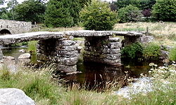 Le clapper bridge traversant l'East Dart
