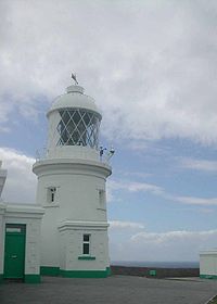
Pendeen
- Pendeen
-
50°9′8″N 5°39′42″O / 50.15222, -5.66167
Pendeen est un village cornouaillais près de Trewellard et la ville de Penzance. Le village est dans la paroisse de St Just (St Just in Penwith(en)).
On peut y observer des phoques. La mine d'étain de Geevor et la phare de Pendeen sont proche et l'église de Saint-Jean a été construite par les habitants vers 1851.
Wikimedia Foundation.
2010.
Contenu soumis à la licence CC-BY-SA. Source : Article Pendeen de Wikipédia en français (auteurs)
Regardez d'autres dictionnaires:
Pendeen — infobox UK place country = England latitude= 50.1521 longitude= 5.6618 official name= Pendeen population = shire district= Penwith shire county = Cornwall region= South West England constituency westminster= Falmouth and Camborne post town =… … Wikipedia
Pendeen Lighthouse — p4 Pendeen Lighthouse Leuchtturm von Pendeen Ort … Deutsch Wikipedia
Pendeen Lighthouse — In the far west of Cornwall Pendeen Lighthouse is owned by Trinity House. It was established in 1900 and its light range is 16 miles out to sea. It has a 17 metres high tower. It perches on the cliffs near Pendeen. The lighthouse became automated … Wikipedia
Fogou von Pendeen — Das Fogou von Pendeen (auch Pendeen Vau genannt) ist eine archäologische Fundstätte 5 Kilometer nördlich von St Just in Penwith auf einer Farm in der Nähe des Leuchttfeuers Pendeen in Cornwall. In dem eponymen Dorf wurde William Borlase jun … Deutsch Wikipedia
St Just in Penwith — St Just ( kw. Lanust) is a town and civil parish in the district of Penwith, Cornwall in England, UK. The parish encompasses the town of St Just and the nearby settlements of, Pendeen and Kelynack and is bounded by the parishes of Morvah to the… … Wikipedia
Fogou — The word Fogou or Fougou as it can also be spelt, derives from fogo which was the Cornish word for cave. A fogou (pronounced foo goo ) is an underground structure which is found in many Iron Age defended settlements throughout northern Europe… … Wikipedia
Diocese of Truro — Location Ecclesiastical province Canterbury Archdeaconries Bodmin, Cornwall Coordinates … Wikipedia
Liste europäischer Leuchttürme — In dieser Liste befindet sich eine Auswahl europäischer Leuchttürme. Inhaltsverzeichnis 1 Bulgarien 2 Dänemark 3 Deutschland 4 England … Deutsch Wikipedia
Souterrains in Cornwall — Carn Euny nach Blight/Borlase 1868 Die Souterrains in Cornwall werden lokal als „Fogou“ bezeichnet. Der Name geht auf das kornische Wort für Höhle zurück (ähnlich auch lokal „Weem“ (von uamh‚ Höhle) für die Souterrains in Schottland). Die… … Deutsch Wikipedia
Penwith — ( kw. Pennwydh) is a local government district in Cornwall, England, United Kingdom, whose council is based in Penzance. The district covers all of the Penwith peninsula, the toe like promontory of land at the western end of Cornwall and which… … Wikipedia

