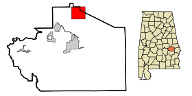
Notasulga
Contenu soumis à la licence CC-BY-SA. Source : Article Notasulga de Wikipédia en français (auteurs)
Regardez d'autres dictionnaires:
Notasulga — Notasulga, AL U.S. town in Alabama Population (2000): 916 Housing Units (2000): 446 Land area (2000): 13.897089 sq. miles (35.993295 sq. km) Water area (2000): 0.055805 sq. miles (0.144535 sq. km) Total area (2000): 13.952894 sq. miles (36.137830 … StarDict's U.S. Gazetteer Places
Notasulga, AL — U.S. town in Alabama Population (2000): 916 Housing Units (2000): 446 Land area (2000): 13.897089 sq. miles (35.993295 sq. km) Water area (2000): 0.055805 sq. miles (0.144535 sq. km) Total area (2000): 13.952894 sq. miles (36.137830 sq. km) FIPS… … StarDict's U.S. Gazetteer Places
Notasulga, Alabama — Town … Wikipedia
Notasulga (Alabama) — Notasulga Pueblo de los Estados Unidos … Wikipedia Español
36866 — Notasulga, Al (Miscellaneous » ZIP Codes) … Abbreviations dictionary
Zora Neale Hurston — Infobox Writer name = Zora Neale Hurston caption = birthdate = birth date|1891|1|7|mf=y birthplace = Notasulga, Alabama, United States deathdate = death date and age|1960|1|28|1891|1|7 deathplace = Fort Pierce, Florida, United States occupation … Wikipedia
Alabama State Route 14 — Infobox road state=AL type=AL route=14 length mi=247 length ref= [ [http://colepages.com/routes125.html Highway Route Info Routes 1 25 ] ] length round= established= direction a=West direction b=East starting terminus= junction= ending terminus=… … Wikipedia
Alabama State Route 81 — Infobox road state=AL type=AL route=81 length mi=10 length ref= [ [http://colepages.com/routes76100.html Highway Route Info Routes 76 100 ] ] length round= established= direction a=South direction b=North starting terminus= junction= near… … Wikipedia
Lee County, Alabama — Infobox U.S. County county = Lee County state = Alabama map size = 150 founded = December 5, 1866 seat = Opelika | largest city = Auburn area total sq mi =616 area land sq mi =609 area water sq mi =7 area percentage = 1.11% census estimate yr =… … Wikipedia
Macon County, Alabama — Infobox U.S. County county = Macon County state = Alabama map size = 150 founded = December 18, 1832 seat = Tuskegee | largest city = Tuskegee area total sq mi =610 area land sq mi =600 area water sq mi =10 area percentage = 1.25% census yr =… … Wikipedia
 États-Unis
 Alabama