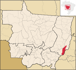
Araguaiana
Contenu soumis à la licence CC-BY-SA. Source : Article Araguaiana de Wikipédia en français (auteurs)
Regardez d'autres dictionnaires:
Araguaiana — Original name in latin Araguaiana Name in other language Araguiana, Registro do Araguaia State code BR Continent/City America/Sao Paulo longitude 15.73389 latitude 51.83139 altitude 287 Population 3512 Date 2012 08 03 … Cities with a population over 1000 database
Araguaiana — Admin ASC 2 Code Orig. name Araguaiana Country and Admin Code BR.14.5101001 BR … World countries Adminstrative division ASC I-II
Муниципалитеты штата Мату-Гросу — … Википедия
Арагуаяна — Муниципалитет Арагуаяна Araguaiana Страна БразилияБразилия … Википедия
Nova Crixás (Goiás) — Nova Crixás Wappen Flagge … Deutsch Wikipedia
Cáceres, Mato Grosso — Cáceres State Mato Grosso Area: 24 797 km² Population: 85 274 (Estimate: 07/2003) Height: 118 m above sea level Postcode (CEP): 78 … Wikipedia
Cuiabá — Municipality The Municipality of Cuiabá From the top, left to right: Cuiabá Cathedral, Santo Antônio Hill behind … Wikipedia
Nossa Senhora do Livramento, Mato Grosso — Nossa Senhora do Livramento Municipality Location of Nossa Senhora do Livramento in Brazil … Wikipedia
Diamantino — is a small town in Mato Grosso state in Brazil. Its has a population of 18.580, and is near Diamantino river. It is 1837 feet above sea level, and sits at the foot of the Mato Grosso plateau. Its history dates from 1730 as a gold mining… … Wikipedia
Chapada dos Guimarães — is a county and a mountain range located in central Brazil, 62 km from the city of Cuiaba, the capital of Mato Grosso State. This range is surrounded by Brazilian savannas (also known as cerrado) and the Amazon rainforest. Many people travel … Wikipedia

