Müllerthal
- Müllerthal
-
Mullerthal
Mullerthal (luxembourgeois: Mëllerdall, allemand: Müllertal) est une section de la commune luxembourgeoise de Waldbillig située dans le district de Grevenmacher et le canton d'Echternach.
Le village a donné son nom à la région dans laquelle il se trouve, aussi appelée Petite Suisse Luxembourgeoise.
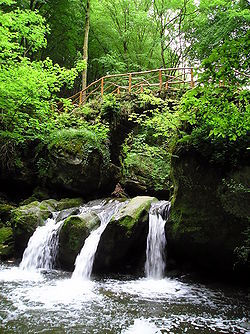
Sur les hauteurs près de la localité, on retrouve les ruines de la "Heringerburg", un ancien château fort. Au sud de Mullerthal, en dessous d'un petit pont, on aperçoit le "Schiessentümpel", qui est la plus haute cascade du pays[1].

Cascade du Schiessentümpel
Notes et références
 Portail du Luxembourg
Catégorie : Localité du canton d'Echternach
Wikimedia Foundation.
2010.
Contenu soumis à la licence CC-BY-SA. Source : Article Müllerthal de Wikipédia en français (auteurs)
Regardez d'autres dictionnaires:
Mullerthal — Mullerthal … Wikipédia en Français
Mullerthal, Luxembourg — Mullerthal (Luxembourgish: Mëllerdall, German: Müllertal) is a village in the commune of Waldbillig, in eastern Luxembourg. As of 2005[update], the village has a population of 146. It lends its name to the alternative name of a region of eastern… … Wikipedia
Luxemburger Schweiz — Der Schiessentümpel im Müllerthal Naturnahe Landschaft des Müllerthals … Deutsch Wikipedia
Luxemburgische Schweiz — Der Schiessentümpel im Müllertal Ein Kletterer an den Sandsteinfelsen im Müllerthal Die Kleine Luxemburger Schweiz bezeichnet eine Gegend im Osten Luxemburgs, welche u. a. die Orte … Deutsch Wikipedia
Waldbillig — Wappen Karte Basisdaten Distrikt … Deutsch Wikipedia
Waldbëlleg — Wappen Karte Basisdaten Distrikt … Deutsch Wikipedia
Petite Suisse luxembourgeoise — 49°42′N 6°30′E / 49.7, 6.5 … Wikipédia en Français
Petite Suisse Luxembourgeoise — Cascade du Schiessentümpel près de Waldbillig … Wikipédia en Français
Little Switzerland (Luxembourg) — Little Switzerland Little Switzerland (Luxembourgish: Kleng Lëtzebuerger Schwäiz, French: Petite Suisse Luxembourgeoise, German: Kleine Luxemburger Schweiz) is a nickname for a region in the east of Luxembourg, bestowed … Wikipedia
Grafschaft Luxemburg — Groussherzogtum Lëtzebuerg (ltz.) Großherzogtum Luxemburg (deu.) Grand Duché de Luxembourg (fra.) … Deutsch Wikipedia
 Mullerthal
 Luxembourg

