Mores Island
- Mores Island
-
Moore's Island
Moore's Island (aussi appelée Mores Island) est une île des Bahamas située dans l'ouest de l'archipel des îles Abacos. La principale agglomération de l'île s'appelle Hard Bargain.
L'île est peu touristique à cause du manque d'eau potable et elle vit principalement de la pêche. L'île n'a pas d'habitants permanents, mais abrite de façon saisonnière des pêcheurs bahaméens et des touristes[1].
L'île a subi d'importants dégâts en 2004, lors du passage des ouragans Frances et Jeanne.
District
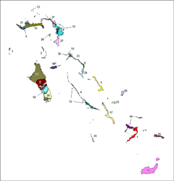
Moore's Island est l'un des 32 districts des Bahamas. Il est composé de l'île de Moore's island ainsi que des îlots alentour et porte le numéro 20 sur la carte.
Sources
Notes et références
 Portail du monde maritime
Catégories : Île des Bahamas | District des Bahamas | Île de la mer des Sargasses
Wikimedia Foundation.
2010.
Contenu soumis à la licence CC-BY-SA. Source : Article Mores Island de Wikipédia en français (auteurs)
Regardez d'autres dictionnaires:
Moore's Island — Géographie Pays Bahamas Archipel … Wikipédia en Français
Chateau de Mores — U.S. National Register of Historic Places … Wikipedia
Long Beach Island — (colloquially known as LBI) is a barrier island and summer colony along the Atlantic Ocean coast of Ocean County, New Jersey in the United States. Aligned north south, the northern portion is generally slightly higher end, low density… … Wikipedia
The Island of the Fay — Das Mezzotinto von John Sartain nach John Martin, das Poe anregte Die Erzählung The Island of the Fay (Die Insel der Fee) von Edgar Allan Poe wurde in Graham s Lady s and Gentleman s Magazine 1841 erstveröffentlicht. Als Motto setzte Poe sein… … Deutsch Wikipedia
Great Abaco — Abaco Inseln Leuchtturm bei Hope Town Gewässer Atlantischer Ozean Anzahl der Inseln etwa 15 Hauptinsel … Deutsch Wikipedia
Little Abaco — Abaco Inseln Leuchtturm bei Hope Town Gewässer Atlantischer Ozean Anzahl der Inseln etwa 15 Hauptinsel … Deutsch Wikipedia
Abaco (Bahamas) — Abaco Inseln Leuchtturm bei Hope Town Gewässer Atlantischer Ozean Archipel … Deutsch Wikipedia
Isla de Moore — Mapa político de las Bahamas. Moore s Island (también llamada Morés Island) es una isla de las Bahamas situada en el oeste del archipiélago de las Islas Ábaco. La principal aglomeración de la isla se llama a Hard Bargain. La isla es poco… … Wikipedia Español
ancient Rome — ▪ ancient state, Europe, Africa, and Asia Introduction the state centred on the city of Rome. This article discusses the period from the founding of the city and the regal period, which began in 753 BC, through the events leading to the… … Universalium
Mahabangbaybay, San Agustin, Romblon — Mahabangbaybay is an urban barangay in the municipality of San Agustin, island of Tablas, province of Romblon, Philippines. According to the 2000 census, it has a population of 1,744 people in 335 households. Its land area is 261.61 hectares.… … Wikipedia
 Bahamas
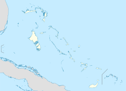 Moore's Island