- McClellan-Palomar Airport
-
Carlsbad (Californie)
 Pour les articles homonymes, voir Carlsbad.
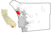 Localisation de Carlsbad sur la carte du comté de San Diego en Californie

Carlsbad est une ville de Californie située dans le comté de San Diego.
La ville avait une population de 90.271 habitants au recensement de 2003. C'est la 81ème plus grande ville de Californie par population. La zone urbaine formée des trois villes de Oceanside, Carlsbad et Escondido au nord du Comté de San Diego recense plus de 500.000 habitants.
Sommaire
Tourisme
C'est la ville où est implanté le Legoland California, un parc d'attraction miniature de la société Lego, géré par la société Merlin Entertainments.
À Carlsbad se tient un musée de la musique américaine (Museum of Making Music, [1]) exposant plus de cinq cents instruments et échantillons audio et vidéo interactifs.
Sport
A Carlsbad se trouve le Carlsbad Gap qui est un "spot" de skateboard renommé.
Y a lieu également le Championnat Mercedes-Benz (PGA Tour), un tournoi de golf.
Économie
- La sociéte iPayOne est basée à Carlsbad. C'est la société ayant acheté pendant un temps les droits d'appellation de l'arène des sports de San Diego.
- Callaway Golf est une société spécialisé dans la fabriation d'équipement de golf.
- La National Association of Music Merchants (NAMM), une association de société productrice de musique a son siège implantée à Carlsbad.
- Carlsbad possède un aéroport (McClellan-Palomar Airport, code AITA: CLD, code OACI : KCRQ, code FAA LID: CRQ).
Personnalité liées à la commune
- Chany Jeanguenin, skateur professionnel : lieu de résidence,
- Tony Hawk, skateur : lieu de naissance,
Catégorie : Ville de Californie

Wikimedia Foundation. 2010.