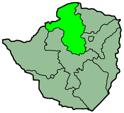
Mashonaland West
- Mashonaland West
-
Mashonaland Occidental
Le Mashonaland Occidental est une province du Zimbabwe. Il occupe une superficie de 57,441 km² pour une population d'approximativement 1.2 million (2002). La capitale de la province est Chinhoyi.
Le Mashonaland Occidental est divisé en 6 districts :
 Portail de l’Afrique
Catégorie : Province du Zimbabwe
Wikimedia Foundation.
2010.
Contenu soumis à la licence CC-BY-SA. Source : Article Mashonaland West de Wikipédia en français (auteurs)
Regardez d'autres dictionnaires:
Mashonaland West — is a province of Zimbabwe. It has an area of 57,441 km² and a population of approximately 1.2 million (2002). Chinhoyi is the capital of the province.Mashonaland West is divided into 6 districts: * Chegutu * Hurungwe * Kadoma * Kariba * Makonde * … Wikipedia
Mashonaland West — Lage der Provinz Mashonaland West in Simbabwe Mashonaland West ist eine Provinz Simbabwes. Sie hat eine Gesamtfläche von 57.441 km² und 1,2 Millionen Einwohner (2002). Ihre Hauptstadt Chinhoyi. West Mashonaland ist ein sehr gegensätzliches Gebiet … Deutsch Wikipedia
Mashonaland West Province — Mashonaland West is a province of Zim … Wikipedia
Mashonaland West Province — Admin ASC 1 Code Orig. name Mashonaland West Province Country and Admin Code ZW.05 ZW … World countries Adminstrative division ASC I-II
Mashonaland — ist das Hauptsiedlungsgebiet der Shona in Simbabwe. Heute teilt es sich auf in drei Provinzen und den Hauptstadtdistrikt: Mashonaland West, Mashonaland Central, Mashonaland East und Harare. Die Provinzhauptstädte sind Chinhoyi, Bindura und… … Deutsch Wikipedia
Mashonaland — Map of Zimbabwe showing Mashonaland Mashonaland is a region in northern Zimbabwe. It is the home of the Shona people. Currently, Mashonaland is divided into three provinces, with a total population of about 3 million: Mashonaland West Mashonaland … Wikipedia
Mashonaland East Province — … Wikipedia
Mashonaland Central Province — … Wikipedia
Mashonaland Central — Lage der Provinz Mashonaland Central in Simbabwe Mashonaland Central ist eine Provinz im Nordosten Simbabwes. Sie ist 28,347 km² groß und beheimatet mit einer Million (2002) Einwohnern etwa 8,5 Prozent der Gesamtbevölkerung des Landes. Bindura… … Deutsch Wikipedia
Mashonaland East — Lage der Provinz Mashonaland East in Simbabwe Mashonaland East ist eine Provinz im Nordosten Simbabwes. Sie ist 32,230 km² groß und hat 1,1 Millionen Einwohner (2002). Marondera ist die Hauptstadt von Mashonaland East. Die Provinz ist in neun… … Deutsch Wikipedia


