Lolo Pass (Oregon)
Contenu soumis à la licence CC-BY-SA. Source : Article Lolo Pass (Oregon) de Wikipédia en français (auteurs)
Regardez d'autres dictionnaires:
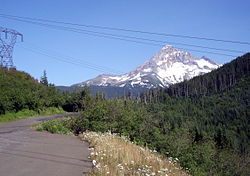
Lolo Pass (Oregon) — Infobox Mountain Pass Name = Lolo Pass Photo = Lolo pass medium with mount hood background P3125.jpeg Caption = Mount Hood visible behind Lolo Pass Elevation = convert|3415|ft|m cite web url = gnis3|1145348 title = Feature Detail Report Lolo Pass … Wikipedia
Lolo — can refer to:These places: * Lolo (volcano), New Britain * Ogooué Lolo province in Gabon * Lolo River, tributary of Ogooué River, Gabon * Lolo, Montana * Lolo Pass (Idaho Montana) * Lolo Pass (Oregon) * Lolo Creek, Montana * Lolo National Forest … Wikipedia
Oregon National Historic Trail — Verlauf der Route Lage: Missouri, Kansas, Nebraska … Deutsch Wikipedia
Oregon Trail — Oregon National Historic Trail Besonderheit: Historische Handels und Siedlungsroute des 19. Jahrhunderts über die Rocky … Deutsch Wikipedia
Oregon Trail — For other uses, see Oregon Trail (disambiguation). Oregon Trail The route of the Oregon Trail shown on a map of the western United States from Independence, Missouri (on the eastern end) to Oregon City, Oregon (on the western end) … Wikipedia
Senda de Oregón — Ruta Histórica de Oregón (Oregon National Historic Trail) Categoría UICN V (Paisajes terrestres/marinos protegidos) Un mapa histórico de la ruta … Wikipedia Español
Sandy River (Oregon) — Geobox | River name = Sandy River category = River image size = image caption = Sandy River and Mount Hood etymology = Named Quicksand River in 1805 by Lewis and Clark because of emence quantitys of sand at the mouth; apparently shortened to… … Wikipedia
South Pass — x South Pass Am South Pass, Blick Richtung Westen … Deutsch Wikipedia
Mount Hood Village, Oregon — CDP … Wikipedia
Muddy Fork (Oregon) — Coordinates: 45°23′40″N 121°49′04″W / 45.39444°N 121.81778°W / 45.39444; 121.81778 … Wikipedia

 États-Unis


