Local Area Augmentation System
- Local Area Augmentation System
-

Pour les articles homonymes, voir
LAAS.
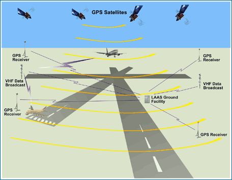
Le Local Area Augmentation System (LAAS) est un système d'atterrissage d'avion tous temps basé sur la correction différentielle temps réel du signal GPS. Dans un aéroport, des récepteurs GPS locaux de référence envoient des données à un système central à l'aéroport. Ces données sont utilisées pour former un message de correction, qui est alors transmis aux utilisateurs (avions) par l'intermédiaire d'une liaison de transmission de données VHF. Un récepteur embarqué dans l'avion utilise cette information pour corriger les signaux GPS, et peut alors fournir un affichage standard ILS à utiliser en naviguant en approche de précision. L'Organisation de l'aviation civile internationale (OACI) appelle ce type de système un Ground Based Augmentation System (GBAS).
En 2001, le LAAS était capable de réaliser une précision ILS de catégorie I, de 16 m en latéral et 4 m en vertical. Le but du programme LAAS était de fournir une précision ILS de catégorie III. La FAA n'a pas spécifié la précision minimale exigée pour les erreurs ILS de catégorie III. Cependant, une approche ILS de catégorie III permet à l'avion d'atterrir avec une visibilité zéro en utilisant des systèmes d'auto-atterrissage et indique une grande précision < 1 m[1].
Voir aussi
Références
Wikimedia Foundation.
2010.
Contenu soumis à la licence CC-BY-SA. Source : Article Local Area Augmentation System de Wikipédia en français (auteurs)
Regardez d'autres dictionnaires:
Local Area Augmentation System — The Local Area Augmentation System (LAAS) is an all weather aircraft landing system based on real time differential correction of the GPS signal. Local reference receivers send data to a central location at the airport. This data is used to… … Wikipedia
local area augmentation system — The augmentation to the global positioning system (GPS) to meet Cat I, Cat II, and CAT III precision approach accuracy, integrity, continuity, and availability requirements. The system is ground based and comprises a ground reference station at… … Aviation dictionary
Local Area Augmentation System — Ein Ground Based Augmentation System (GBAS, dt. Bodengestütztes Regionales Erweiterungssystem) ist ein auf Differential GPS beruhendes Verfahren zur Erzielung einer höheren Genauigkeit bei der Bestimmung von Ortskoordinaten. Dies ist notwendig,… … Deutsch Wikipedia
Wide Area Augmentation System — FAA WAAS logo … Wikipédia en Français
Wide Area Augmentation System — BenefitsWAAS addresses all of the navigation problem , providing highly accurate positioning that is extremely easy to use, for the cost of a single receiver installed on the aircraft. Ground and space based infrastructure is relatively limited,… … Wikipedia
Wide Area Augmentation System - WAAS — FAA WAAS logo … Wikipédia en Français
GNSS Augmentation — Augmentation of a Global Navigation Satellite System (GNSS) is a method of improving the navigation system s attributes, such as accuracy, reliability, and availability, through the integration of external information into the calculation process … Wikipedia
Joint Precision Approach and Landing System — The Joint Precision Approach and Landing System (JPALS) is a military, all weather landing system based on real time differential correction of the GPS signal, augmented with a local area correction message, and transmitted to the user via secure … Wikipedia
Global navigation satellite system — (GNSS) is the standard generic term for satellite navigation systems that provide autonomous geo spatial positioning with global coverage. A GNSS allows small electronic receivers to determine their location (longitude, latitude, and altitude) to … Wikipedia
Instrument landing system — The Instrument Landing System (ILS) is a ground based instrument approach system that provides precision guidance to an aircraft approaching a runway, using a combination of radio signals and, in many cases, high intensity lighting arrays to… … Wikipedia
 Architecture du LAAS
 GPS |
GPS |  /
/  GLONASS
 Galileo |
  Beidou |
  IRNSS
IRNSS