OpenSeaMap
- OpenSeaMap
-
OpenSeaMap est un projet dont l'objectif est de collecter les informations nautiques librement utilisables, et de les coupler à des informations géolocalisées avec le but de créer une carte marine mondiale. Cette carte est disponible sur le site d'OpenSeaMap, et peut également être téléchargée comme carte numérique pour des applications hors-ligne. L'une des principales sources d'informations sont les données issues d'OpenStreetMap.

Logo officiel d'OpenSeaMap
Voir aussi
Références
Articles connexes
Liens externes
Wikimedia Foundation.
2010.
Contenu soumis à la licence CC-BY-SA. Source : Article OpenSeaMap de Wikipédia en français (auteurs)
Regardez d'autres dictionnaires:
OpenSeaMap — URL openseamap.org Slogan The Free Nautical Chart Commercial? No … Wikipedia
OpenSeaMap — openseamap.org Motto The Free Nautical Chart Komm … Deutsch Wikipedia
OpenStreetMap — Logo officiel URL www.openstreetmap.org Description Service collaboratif de cartographie … Wikipédia en Français
General Bathymetric Chart of the Oceans — Bathymetrische Karte Atlantik … Deutsch Wikipedia
Nautical chart — A nautical chart is a graphic representation of a maritime area and adjacent coastal regions. Depending on the scale of the chart, it may show depths of water and heights of land (topographic map), natural features of the seabed, details of the… … Wikipedia
OpenStreetMap — http://www.openstreetmap.org Motto The Free Wiki World Map … Deutsch Wikipedia
OpenStreetMap — of Cambridge, England URL … Wikipedia
Seekarte — Ausschnitt einer elektronischen Seekarte der Beringstraße Eine Seekarte ist eine Karte, die für die Schifffahrt die Seewege und Küsten, Untiefen, Seezeichen, Fahrrinnen etc. von einem bestimmten Seegebiet (z. B. Nordsee) darstellt. Die … Deutsch Wikipedia
Garmin — Ltd. Rechtsform Aktiengesellschaft ISIN CH0114405324 Gründung … Deutsch Wikipedia
Global Positioning System — NAVSTAR Satellit der zweiten Generation Bewegung der Satelliten über der Erde Global Positioning System (GPS), offiziell NAVSTAR GPS, ist ein globales Navigationssatelliten … Deutsch Wikipedia

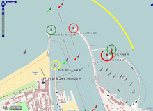 Port de Warnemünde sur OpenSeaMap