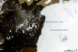
Glacier Humboldt
Contenu soumis à la licence CC-BY-SA. Source : Article Glacier Humboldt de Wikipédia en français (auteurs)
Regardez d'autres dictionnaires:
Humboldt — may refer to:People* Alexander von Humboldt, a German natural scientist * Wilhelm von Humboldt (his brother), a linguist, philosopher, and diplomat Places Counties * Humboldt County, California * Humboldt County, Iowa * Humboldt County, Nevada… … Wikipedia
Humboldt Glacier — ▪ glacier, Greenland largest known glacier in the world, northwestern Greenland, 210 miles (340 km) north northeast of Dundas. It rises to a height of 328 feet (100 m) and discharges into the Kane Basin along a 60 mile (100 km) front. It… … Universalium
Humboldt-Gletscher — 79.5 63 Koordinaten: 79° 30′ 0″ N, 63° 0′ 0″ W … Deutsch Wikipedia
Humboldt — Cette page d’homonymie répertorie les différents sujets et articles partageant un même nom. Humboldt est un nom de famille notamment porté par : Alexander von Humboldt, naturaliste et explorateur allemand (1769 1859) ; Wilhelm von… … Wikipédia en Français
Humboldt Glacier — geographical name glacier NW Greenland … New Collegiate Dictionary
Pico Humboldt — Infobox Mountain Name = Pico Humboldt Photo = Humboldt peak.jpg Caption = Pico Humboldt as seen from the Coromoto La Verde trail. Elevation = convert|4940|m|ft|0 Location = Mérida, Venezuela Range = Sierra Nevada, Andes Prominence = Coordinates … Wikipedia
Perito Moreno Glacier — Coordinates: 50°29′S 73°03′W / 50.483°S 73.05°W / 50.483; 73.05 … Wikipedia
Jean Malaurie — à bord du navire hydrographique soviétique Malygin, au large d Ouélen, durant son expédition en Tchoukotka, août … Wikipédia en Français
Parc national de Redwood — Parcs d État et national Redwood Catégorie UICN II (parc national) Pays … Wikipédia en Français
Earth Sciences — ▪ 2009 Introduction Geology and Geochemistry The theme of the 33rd International Geological Congress, which was held in Norway in August 2008, was “Earth System Science: Foundation for Sustainable Development.” It was attended by nearly… … Universalium
 Danemark
 Groenland