Langiden

Langiden
Langiden
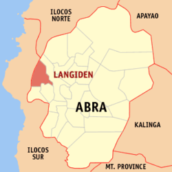
Localisation de Langiden (en rouge) dans la province d'Abra.
Administration
Pays Drapeau des Philippines Philippines
Région Région administrative de la Cordillère
Province Abra
Barangays 6
Classe de revenus 5e
Caractéristiques
Population 2 998 hab.
Géographie
Latitude
Longitude
17° 35′ 00″ N 120° 34′ 01″ E / 17.5833, 120.56717° 35′ 00″ Nord
       120° 34′ 01″ Est
/ 17.5833, 120.567
  

Langiden est une municipalité située dans la province d'Abra, aux Philippines.

Voir aussi


Villes d'Abra
Bangued · Boliney · Bucay · Bucloc · Daguioman · Danglas · Dolores · La Paz · Lacub · Lagangilang · Lagayan · Langiden · Licuan-Baay · Luba · Malibcong · Manabo · Peñarrubia · Pidigan · Pilar · Sallapadan · San Isidro · San Juan · San Quintin · Tayum · Tineg · Tubo · Villaviciosa

Wikimedia Foundation. 2010.

Contenu soumis à la licence CC-BY-SA. Source : Article Langiden de Wikipédia en français (auteurs)

Игры ⚽ Нужно решить контрольную?

Regardez d'autres dictionnaires:

  • Langiden — Municipality of Langiden Lage von Langiden in der Provinz Abra Basisdaten Bezirk: Regier …   Deutsch Wikipedia

  • Langiden — Original name in latin Langiden Name in other language Langiden State code PH Continent/City Asia/Manila longitude 17.5771 latitude 120.564 altitude 57 Population 0 Date 2011 07 31 …   Cities with a population over 1000 database

  • Langiden, Abra — Infobox Philippine municipality infoboxtitle = Municipality of Langiden sealfile = locatormapfile = Ph locator abra langiden.png caption = Map of Abra showing the location of Langiden. region = Cordillera Administrative Region province = Abra… …   Wikipedia

  • Bangued — Municipality of Bangued Lage von Bangued in der Provinz Abra Basisdaten Bezirk: Regierungs …   Deutsch Wikipedia

  • Bangued, Abra — Infobox Philippine municipality infoboxtitle = Municipality of Bangued sealfile = Ph seal abra bangued.png locatormapfile = Ph locator abra bangued.png caption = Map of Abra showing the location of Bangued. region = Cordillera Administrative… …   Wikipedia

  • Daguioman, Abra — Daguioman   Municipality   Seal …   Wikipedia

  • Danglas, Abra — Danglas   Municipality   Map of Abra showing the location of Danglas …   Wikipedia

  • Dolores, Abra — Dolores   Municipality   Seal …   Wikipedia

  • Malibcong, Abra — Malibcong   Municipality   Map of Abra showing the location of Malibcong …   Wikipedia

  • Manabo, Abra — Manabo   Municipality   Seal …   Wikipedia

Share the article and excerpts

Direct link
Do a right-click on the link above
and select “Copy Link”