- Lac Rapel
-
Lac Rapel 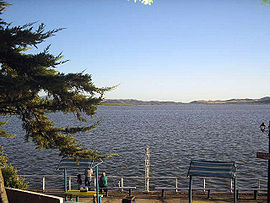
Administration Pays  Chili
ChiliGéographie Latitude
LongitudeSuperficie 80 km2 Altitude 110 m Volume 695 millions de m3 Hydrographie Alimentation Río Cachapoal,
Río TinguiriricaÉmissaire(s) Río Rapel modifier 
Le Lac Rapel est un lac artificiel chilien, situé dans la Région du Libertador General Bernardo O'Higgins. Situé dans Chaîne côtière chilienne, il est alimenté par les fleuves Cachapoal et Tinguiririca. Il donne, à son tour, naissance au Río Rapel.
Le barrage a été construit pour permettre la mise en service de la centrale hydroélectique de Rapel, d'une puissance de 350 MW.
Catégorie :- Lac du Chili

Wikimedia Foundation. 2010.