An'naka, Gunma
- An'naka, Gunma
-
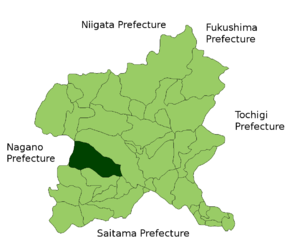
Annaka
Annaka (安中市; -shi) est une ville du Japon de la préfecture de Gunma.
En 2006, la ville avait une population de 65,494 habitants, une densité de 466,49 hab/km² et une superficie de 276,34 km².
La ville a été fondée le 1er novembre 1958.
 Portail du Japon
Catégories : Ville du Japon | Préfecture de Gunma
Wikimedia Foundation.
2010.
Contenu soumis à la licence CC-BY-SA. Source : Article An'naka, Gunma de Wikipédia en français (auteurs)
Regardez d'autres dictionnaires:
Prefectura de Gunma — Gunma 群馬県 Gunma ken Prefectura de Japón … Wikipedia Español
Annaka, Gunma — Japanese city | Name = Annaka JapaneseName = 安中市| Region = Kantō Prefecture = Gunma Prefecture District = Area km2 = 276.34| Population = 62299 PopDate = October 1, 2007 Density km2 = 225.44 Mayor = Coords= coord|36|20|N|138|53|E|region:JP… … Wikipedia
List of mergers in Gunma Prefecture — The following is a list of mergers that occurred in the 2000s in Gunma Prefecture, Japan.(as of October 1, 2006)Mergers from April 1, 2003 to March 31, 2004* On April 1, 2003 the town of Manba and the village of Nakasato from Tano District merged … Wikipedia
Ōta Station (Gunma) — Ōta Station 太田駅 Elevated station building Location Prefecture … Wikipedia
Matsuida, Gunma — Matsuida (松井田町, Matsuida machi?) was a town located in Usui District, Gunma, Japan. As of 2003, the town had an estimated population of 16,556 and a density of 94.58 persons per km². The total area was 175.05 km². On March 18, 2006 Matsuida was… … Wikipedia
Osaka, Gunma — Not to be confused with Ōsaka. Osaka (小坂村, osaka mura?) is a dissolved village once belonging to the Kanra District in the south western portion of Gunma Prefecture. It presently corresponds to Osaka region in Shimonita. Geography Rivers: Kabura… … Wikipedia
Toyoaki, Gunma — Toyoaki (豊秋村; mura) was a village located in Gunma, Japan during the years 1889 1954.HistoryToyoaki Village was formed in 1889 as a result of the merging of three villages: Ishihara Village, Naka Village, and Yunoue (Miyuukida) Village. On April… … Wikipedia
List of dissolved districts of Japan — A district of Japan is dissolved when all towns or villages in the district become cities or are merged into the city. The following is a list of dissolved districts of Japan.The date shown is the day the district was dissolved i.e. the district… … Wikipedia
Liste der Wahlkreise zum Shūgiin — Die 300 Wahlkreise zum Shūgiin Dies ist eine Liste der Wahlkreise zum Shūgiin, dem japanischen Unterhaus, seit der Wahlrechtsreform von 1994. Die darin festgelegten Einmandatswahlkreise kommen seit der Shūgiin Wahl 1996 zur Anwendung. Einzelne… … Deutsch Wikipedia
List of Districts of the House of Representatives of Japan — As of 2005, the House of Representatives of Japan is elected from a combination of multi member districts and single member districts. Currently, 180 members are elected from 11 multi member districts, and 300 members are elected from single… … Wikipedia