Kensal Rise
Contenu soumis à la licence CC-BY-SA. Source : Article Kensal Rise de Wikipédia en français (auteurs)
Regardez d'autres dictionnaires:
Kensal Rise railway station — Infobox London station name = Kensal Rise manager = London Overground zone = 2 locale = Kensal Green borough = London Borough of Brent start=1873 platforms=2 railexits0405=0.200 railexits0506=0.201 railexits0607=0.952 railcode=KNRKensal Rise… … Wikipedia
Kensal Green & Harlesden railway station — Kensal Green Harlesden was a railway station on the North London Line. It opened in 1861, and closed in 1873. On closure, it was replaced by Kensal Rise railway station.ources*Kensal Rise railway station … Wikipedia
Kensal — refers to: *Kensal Green, also known as Kensal Rise, part of London, United Kingdom *Kensal Town, part of London, United Kingdom *Kensal, North Dakota, United States … Wikipedia
Kensal Green — infobox UK place country = England map type = Greater London region= London population= official name= Kensal Green london borough= Brent constituency westminster= Brent South post town= LONDON postcode district = NW10 (also NW6 in some parts)… … Wikipedia
Kensal Green station — London stations name = Kensal Green manager = London Underground [Transport for London [http://www.tfl.gov.uk/corporate/media/newscentre/3736.aspx Safety boost as London Underground to take control of 11 Silverlink stations] 5 December 2006.]… … Wikipedia
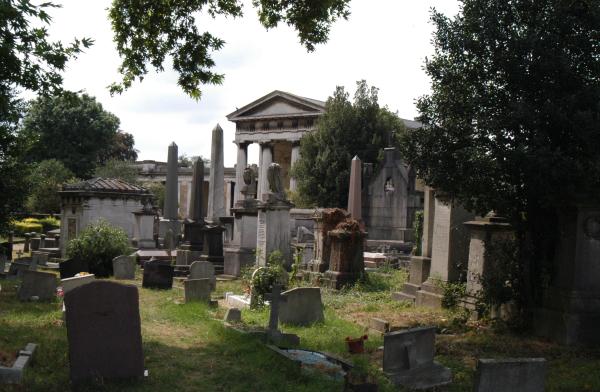
Kensal Green — Le cimetière de Kensal Green 51°31′49″N … Wikipédia en Français
Kensal Green — London Borough of Brent Lage in Greater London Status London Borough Region Greater Lo … Deutsch Wikipedia
Old Oak Common railway station — Crossrail Interchange Proposed location … Wikipedia
Royal Borough of Kensington and Chelsea — London borough, Royal borough … Wikipedia
Notting Hill — For the film, see Notting Hill (film). For Notting Hill in Melbourne, Australia, see Notting Hill, Victoria. Coordinates: 51°30′35″N 0°12′15″W / 51.5096°N 0.2043°W … Wikipedia
 Le cimetière de Kensal Green
 Ce site est desservi par la station de métro : Kensal Green.
 Portail de Londres