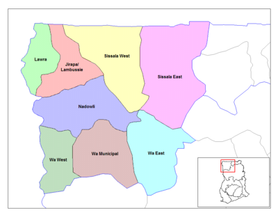
Jirapa/Lambussie
- Jirapa/Lambussie
-
Jirapa

Les districts de la région du Haut Ghana occidental
Le district de Jirapa (officiellement Jirapa District, en Anglais) est l’un des 9 districts de la Région du Haut Ghana occidental au Ghana.
Anciennement, district de Jirapa/Lambussie, ce district perd une partie de sa surface et de sa population le 29 février 2008 au profit du nouveau district de Lambussie Karni.
Villes et villages du district
- Jirapa
- Hamile
- Tizza
- Billaw
- Karni
|
- Samoa
- Han
- Sabuli
- Tapomo
- Nimbare
|
- Chapuri
- Suggo (Suke)
- Piina
- Kuunkyeni
- Kunzokala
|
- Tampala
- Ullo (Vlo)
- Kogri
- Kpari
|
Voir aussi
Sources
 Portail de l’Afrique
Catégorie : District du Ghana
Wikimedia Foundation.
2010.
Contenu soumis à la licence CC-BY-SA. Source : Article Jirapa/Lambussie de Wikipédia en français (auteurs)
Regardez d'autres dictionnaires:
Jirapa Lambussie — Admin ASC 2 Code Orig. name Jirapa Lambussie Country and Admin Code GH.11.7647381 GH … World countries Adminstrative division ASC I-II
Jirapa/Lambussie District — Lage des Distrikts Jirapa/Lambussie innerhalb der Upper West Region Land … Deutsch Wikipedia
Jirapa/Lambussie District — The Jirapa/Lambussie District is a district of Ghana in the Upper West Region. The Jirapa/Lambussie District lies in the northwestern corner of the Upper West Region of Ghana. The capital of the district is Jirapa. It shares boundaries to the… … Wikipedia
Jirapa — Pays Ghana Région Région du Haut Ghana occidental Catégorie de District Ordinaire Gouverneur Benard K. Puozuing … Wikipédia en Français
List of Ghana Parliament constituencies — This is a list of the 230 constituencies currently represented in the Parliament of the Republic of Ghana, as at the December 2004 parliamentary election. [cite web |url=http://www.parliament.gh/faq.php |title=The Parliament of Ghana FAQ s… … Wikipedia
Bezirke in Ghana — Die Distrikte Ghanas 2006 Die Distrikte von Ghana, wie die Bezirke in Ghana heißen, wurden seit der Unabhängigkeit des Landes verschiedentlich neu organisiert. Die Abgrenzung der Distrikte geschah häufig im Spannungsfeld unklarer ethnischer… … Deutsch Wikipedia
GH-UW — Upper West Region Obere Westregion Basisdaten Hauptstadt: Wa Regionalminister: George Hikah Benson … Deutsch Wikipedia
Wa East District — Lage des Distrikts Wa East innerhalb der Upper West Region Land … Deutsch Wikipedia
Wahlbezirke Ghanas — Die Liste Wahlbezirke Ghanas führt alle seit 2004 bestehenden 230 Wahlkreise Ghanas auf, in denen bei den Parlamentswahlen jeweils ein Direktkandidat im Mehrheitswahlrecht für einen Sitz im Parlament gewählt wird. Noch bei den Parlamentswahlen… … Deutsch Wikipedia
Nadowli West (Ghana parliament constituency) — Nadowli West Parliamentary constituency Nadowli West is in the Nadowli District of the Upper West Region of Ghana Created … Wikipedia


