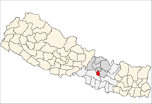
District de Sindhulpalchok

District de Sindhulpalchok

27°46′N 85°42′E / 27.767, 85.7

District de Sindhulpalchok
सिन्धुपाल्चोक जिल्ला

Accéder aux informations sur cette image nommée Lalitpur district location.png.
  •       District de Sindhulpalchok
  •       Autres districts de la zone de la Bagmati
  •       Autres zones de la région Centre
  •       Autres districts, zones et régions
Administration
Pays Drapeau du Népal Népal
Région Région Centre
Zone Bagmati
Type District
Chef-lieu Chautara
Géographie
Superficie 2 542 km²
Démographie
Densité 120,3 hab./km²

Le district de Sindhulpalchok – en népalais : सिन्धुपाल्चोक जिल्ला – est l'un des 75 districts du Népal. Il est rattaché à la zone de la Bagmati et à la région de développement Centre.


Wikimedia Foundation. 2010.

Contenu soumis à la licence CC-BY-SA. Source : Article District de Sindhulpalchok de Wikipédia en français (auteurs)

Игры ⚽ Поможем решить контрольную работу

Regardez d'autres dictionnaires:

  • District De Sindhulpalchok — सिन्धुपाल्चोक जिल्ला …   Wikipédia en Français

  • District de sindhulpalchok — सिन्धुपाल्चोक जिल्ला …   Wikipédia en Français

  • District De Dolpa — डोल्पा जिल्ला …   Wikipédia en Français

  • District de dolpa — डोल्पा जिल्ला …   Wikipédia en Français

  • District De Morang — मोरङ जिल्ला …   Wikipédia en Français

  • District De Sunsari — सुनसरी जिल्ला …   Wikipédia en Français

  • District de morang — मोरङ जिल्ला …   Wikipédia en Français

  • District de sunsari — सुनसरी जिल्ला …   Wikipédia en Français

  • District De Bhojpur (Népal) — Pour les articles homonymes, voir District de Bhojpur. District de Bhojpur भोजपुर जिल्ला …   Wikipédia en Français

  • District De Dhankuta — धनकुटा जिल्ला …   Wikipédia en Français

Share the article and excerpts

Direct link
Do a right-click on the link above
and select “Copy Link”