District de Grant

District de Grant

37° 50′ 00″ S 140° 47′ 00″ E / -37.83333, 140.78333

District de Grant
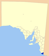
Localisation de la LGA
Données générales
Pays Drapeau d'Australie Australie
État ou Territoire Australie-Méridionale
Région Limestone Coast
Superficie 1 906 km²
Population 7 868 hab. (2006)
Densité 4,1 hab./km²
Administration
Nom du Conseil Conseil du district de Grant
Siège du Conseil Mount Gambier
Maire Don Pegler
Site web http://www.grant.sa.gov.au

Le district de Grant (District of Grant) est la zone d'administration locale la plus au sud de l'Australie-Méridionale en Australie. Elle est située sur la Limestone Coastet a pour siège la ville de Mount Gambier qui est entourée mais n'appartient pas au district de Grant.

Son économie est basée sur l'agriculture, l'exploitation forestière et la pêche.

Localités

La principale localité du district est Port MacDonnell et les autres localités sont: Allendale East, Blackfellows Caves, Burrungule, Canunda, Cape Douglas, Caroline, Carpenter Rocks Caveton, Compton, Dismal Swamp, Donovans, Eight Mile Creek, German Creek, Glenburnie, Kongrong, Mil-Lel, Mingbool, Moorak, Mount Schank, Nene Valley, O B Flat, Pelican Point, Pleasant Park, Racecourse Bay, Square Mile, Suttontown, Tantanoola, Tarpeena, Wandilo, Wepar, Worrolong, Wye et Yahl.

Références


Wikimedia Foundation. 2010.

Contenu soumis à la licence CC-BY-SA. Source : Article District de Grant de Wikipédia en français (auteurs)

Игры ⚽ Поможем написать курсовую

Regardez d'autres dictionnaires:

  • Grant County Schools — is the operating school district within Grant County, West Virginia. It is governed by the Grant County Board of Education.choolsHigh schools*Petersburg High School [http://www.grantcountyschools.com/ grant8/] Elementary schools*Dorcas Elementary …   Wikipedia

  • Grant Joint Union High School District — Infobox Education in the United States name= Grant Joint Union High School District imagesize= motto= The purpose of education is to free individuals from their personal limitations motto translation= streetaddress= 1333 Grand Avenue city=… …   Wikipedia

  • Grant-Kohrs Ranch National Historic Site — Infobox protected area | name = Grant Kohrs Ranch National Historic Site caption = locator x = 67 locator y = 28 location = Powell County, Montana, USA nearest city = Deer Lodge, MT lat degrees = 46 lat minutes = 24 lat seconds = 30 lat direction …   Wikipedia

  • Grant Park (Chicago) — Grant Park U.S. National Register of Historic Places …   Wikipedia

  • District Council of Grant — South Australia Location of the District Council of Grant Population: 8,652( …   Wikipedia

  • District X — (Mutant Town) District X, as depicted in New X Men #127. Publication information Publisher Marvel Comics …   Wikipedia

  • Grant, Michigan — Grant is a city in Newaygo County in the U.S. state of Michigan. As of the 2000 census, the city population was 881. As of 2005 the Newaygo County Economic Development Office reports a population of 934. The city is on the boundary between Grant… …   Wikipedia

  • District Council of Grant — Lage des Grant Council in South Australia Basisdaten Bundesstaat: South Australia Hauptort: Mount Gambier …   Deutsch Wikipedia

  • Grant Council — District Council of Grant Lage des Grant Council in South Australia Gliederung …   Deutsch Wikipedia

  • Grant Elementary School District — (also known as Grant Elementary School) is its own independent public school district combined as a school, in Redding, California. It is the smallest school district in Redding, located in the far westside.The district serves about 600 pupils in …   Wikipedia

Share the article and excerpts

Direct link
Do a right-click on the link above
and select “Copy Link”