Defford
- Defford
-
52° 05′ 14″ N 2° 07′ 09″ W / 52.0873, -2.1191
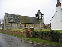
Le village anglais de Defford dans le Worcestershire.
Defford est un petit village du comté de Worcestershire, Angleterre, il est situé entre la ville de Pershore et de Upton-upon-Severn.
Lieux remarquables
- L'école primaire appelée "Defford cum Besford First School"
- Trois pub.
Le champ d'aviation de Defford
En 1941, lors de la seconde guerre mondiale, une base aérienne destinée principalement à tester les radars qui étaient fabriqués à Malvern, la ville voisine, y fut construite.
Liens externes
Sur les autres projets Wikimedia :
Wikimedia Foundation.
2010.
Contenu soumis à la licence CC-BY-SA. Source : Article Defford de Wikipédia en français (auteurs)
Regardez d'autres dictionnaires:
Defford — Coordinates: 52°05′14″N 2°07′09″W / 52.087346°N 2.119104°W / 52.087346; 2.119104 … Wikipedia
RAF Defford — was a Royal Air Force station (airfield) in Worcestershire, England during the Second World War.Construction of RAF Defford was completed in 1941, and for a few months the airfield was used as a satellite station by the Wellington bombers of 23… … Wikipedia
MERLIN — For other uses, see Merlin (disambiguation). Multi Element Radio Linked Interferometer Network A map showing the locations of the antennas used in MERLIN Organization … Wikipedia
RAF Oakhanger — Infobox Military Unit unit name=RAF Oakhanger caption=Station badge dates=1966–2003 country=United Kingdom branch=Royal Air Force command structure=RAF Odiham type= role=Communications size= current commander= garrison= garrison label= ceremonial … Wikipedia
Automatic Gun-Laying Turret — The British Automatic Gun Laying Turret (AGLT) was a radar aimed FN50 turret fitted to some Lancaster bombers in 1944. The AGLT system was devised to allow a target to be tracked and fired on in total darkness, the target s range being accurately … Wikipedia
River Avon, Warwickshire — Infobox River river name = River Avon image size = 300px caption = The River Avon by the Royal Shakespeare Theatre in Stratford upon Avon, Warwickshire origin = Naseby, Northamptonshire mouth = River Severn, Tewkesbury basin countries = England,… … Wikipedia
Droitwich Spa — Coordinates: 52°16′01″N 2°09′11″W / 52.267°N 2.153°W / 52.267; 2.153 … Wikipedia
Jodrell Bank Observatory — The 76 m Lovell Telescope at Jodrell Bank Observatory … Wikipedia
List of RAF stations — This List of RAF stations is a comprehensive list of all stations, airbases, airfields and administrative headquarters of the Royal Air Force past and present.:Note Current RAF Stations will be listed under the currently recognised county of the… … Wikipedia
Royal Signals and Radar Establishment — The Royal Signals and Radar Establishment (RSRE) was a scientific research establishment within the Ministry of Defence of the United Kingdom, located primarily at Malvern in Worcestershire. It was formed in 1976 in an amalgamation of earlier… … Wikipedia

