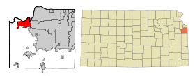
De Soto (Kansas)
Contenu soumis à la licence CC-BY-SA. Source : Article De Soto (Kansas) de Wikipédia en français (auteurs)
Regardez d'autres dictionnaires:
De Soto, Kansas — City Location of De Soto, Kansa … Wikipedia
De Soto High School (De Soto, Kansas) — De Soto High School Location 35000 West 91st Street De Soto, KS, Johnson County, United States Information School type Public High School … Wikipedia
Kansas City metropolitan area — Kansas City, MO KS Common name: Kansas City Metropolitan Area Largest city Kansas City, Missouri Other cities … Wikipedia
Kansas River — Kaw Einzugsgebiet des Kansas River Daten … Deutsch Wikipedia
Kansas locations by per capita income — Kansas has the twenty sixth highest per capita income in the United States, at $20,506 (2000). Its personal per capita income is $29,935 (2003). TOC Kansas counties ranked by per capita incomeThere are 105 counties located in Kansas, one of which … Wikipedia
Kansas (rivière) — 39°6′55″N 94°36′38″O / 39.11528, 94.61056 … Wikipédia en Français
Kansas (riviere) — Kansas (rivière) Kansas (Kaw) La rivière Kansas près de De Soto … Wikipédia en Français
Kansas River — The Kansas River (also known as the Kaw) is a river in northeastern Kansas in the United States. It is the southwestern most part of the Missouri River drainage, which is in turn the northwestern most portion of the extensive Mississippi River… … Wikipedia
Kansas City Metropolitan Area — Infobox Metropolitan Area MSA name = Kansas City, MO KS name = Kansas City Metropolitan Area nickname = City of Fountains largest city = Kansas City, Missouri other cities = Overland Park Kansas City, KS Independence Shawnee Olathe Lee s Summit… … Wikipedia
De Soto School District — The De Soto School District (USD 232) is a public school district in northwestern Johnson County, Kansas, United States. Named after De Soto, Kansas, the district encompasses over 100 square miles (260 km2) serving the city of De Soto and… … Wikipedia
 Pour les articles homonymes, voir De Soto.
 États-Unis
 Kansas