Cité de Bankstown
- Cité de Bankstown
-
Ville de Bankstown
33° 55′ 00″ S 151° 02′ 00″ E / -33.916667, 151.033333
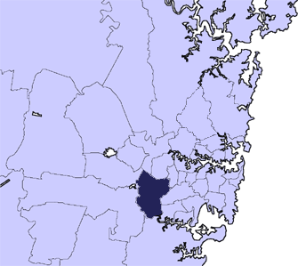
La Ville de Bankstown est une zone d'administration locale environ à 15 km à l'ouest du centre-ville de Sydney, en Nouvelle-Galles-du-Sud (Australie).
L'arrondissement abrite l'aéroport de Sydney: Bankstown Airport (IATA: BWU, ICAO: YSBK)
Arrondissements de la zone d’administration locale
L'arrondissement de Bankstown abrite les quartiers de:
- Bankstown
- Bankstown Aerodrome
- Bass Hill
- Birrong
- Chester Hill
- Chullora
- Condell Park
- East Hills
- Georges Hall
- Greenacre
- Lansdowne
- Leightonfield
- Manahan
- Milperra
- Mount Lewis
- One Tree Point
- Padstow
- Padstow Heights
- Panania
- Picnic Point
- Potts Hill
- Punchbowl
- Revesby
- Revesby Heights
- Sefton
- Villawood
- Yagoona
Référence
- (en) Cet article est partiellement ou en totalité issu d’une traduction de l’article de Wikipédia en anglais intitulé « City of Bankstown ».
 Portail de l’Australie
Wikimedia Foundation.
2010.
Contenu soumis à la licence CC-BY-SA. Source : Article Cité de Bankstown de Wikipédia en français (auteurs)
Regardez d'autres dictionnaires:
Bankstown railway station, Sydney — Bankstown is the principal railway station on the CityRail Bankstown line, for which the line is named. It is itself named for the Sydney suburb of Bankstown in which it is located. The station has a simple island platform, with a crossover at… … Wikipedia
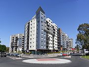
Bankstown, New South Wales — Infobox Australian Place type = suburb name = Bankstown city = Sydney state = nsw caption = Flats in Bankstown lga = City of Bankstown postcode = 2200 pop = 26,000 (2006) area = propval = est = 1795 stategov = Bankstown fedgov = Banks Blaxland… … Wikipedia
Bankstown Airport — Infobox Airport name = Bankstown Airport nativename = nativename a = nativename r = image width = caption = IATA = BWU ICAO = YSBK type = Public owner = operator = Bankstown Airport ltd. city served = location = Bankstown elevation f = 29… … Wikipedia
Bankstown railway line, Sydney — Public transport infrastructure in Sydney logo= name=Bankstown Line transport mode=Commuter rail line line owner=CityRail operation area=Inner west/west map colour=Orange stations number=27 interchange names=Town Hall Central Sydenham Campsie… … Wikipedia
Cité de Sydney — 33°52′S 151°12′E / 33.867, 151.2 … Wikipédia en Français
Cité de Parramatta — 33°49′S 151°00′E / 33.817, 151 … Wikipédia en Français
Electoral district of Bankstown — Bankstown is an electoral district of the Legislative Assembly in the Australian state of New South Wales. It is represented by Tony Stewart of the Australian Labor Party.Members for BankstownElection resultsElection box begin title=New South… … Wikipedia
Canterbury-Bankstown — is a general term used to describe the area located around the Bankstown railway line. The suburbs of the Canterbury Bankstown region are not specific to the local government areas of City of Canterbury and the City of Bankstown but includes many … Wikipedia
History of the Canterbury-Bankstown Bulldogs — The history of the Canterbury Bankstown Bulldogs stretches from the 1930s to the present day. Based in Belmore, a suburb of Sydney, the Bulldogs in 1935 were admitted to the New South Wales Rugby Football League (NSWRFL) competition, a… … Wikipedia
Ville de Bankstown — 33° 55′ 00″ S 151° 02′ 00″ E / 33.916667, 151.033333 … Wikipédia en Français