Bubiyan
- Bubiyan
-
29°47′N 48°11′E / 29.783, 48.183
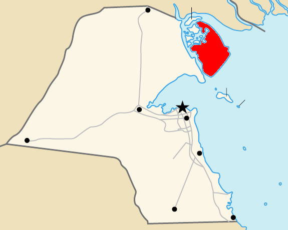
L'île de Bubiyan (en arabe جزيرة بوبيان, se prononce Boubiyane) est la plus grande île de la côte koweitienne avec une superficie de 863 km² situé dans le golfe Persique à proximité immédiate du continent.
Historique
Lorsque les frontières avec l'Irak sont définies par les accords d'Akir de 1922-1923, huit îles dont Bubiyan sont rattachées au Koweït. Elle n'est alors occupés que par quelques villages de pécheurs.
Un pont autoroutier de 2 380 mètres de long fut construit par Bouygues Construction pour relier l'île au continent. Durant le guerre du golfe de 1990/1991, ce pont fut détruit puis reconstruit en 1995[1].
En novembre 2004, la construction d'un port pour conteneurs et d'une zone de libre échange sur cette île a été décidé[2]. En avril 2010, la première phase de ce projet est terminée et la seconde démarre. La capacité annuelle annoncée est de 2,4 millions équivalent vingt pieds[3].
Notes et références
Wikimedia Foundation.
2010.
Contenu soumis à la licence CC-BY-SA. Source : Article Bubiyan de Wikipédia en français (auteurs)
Regardez d'autres dictionnaires:
Bubiyan — Vorlage:Infobox Insel/Wartung/Bild fehltVorlage:Infobox Insel/Wartung/Höhe fehlt Bubiyan Gewässer Persischer Golf Geographische Lage … Deutsch Wikipedia
Bubiyan — Isla Bubiyan جزيرة بوبيان Localización País Kuwait Coordenadas … Wikipedia Español
Būbiyān — ▪ island, Kuwait island of Kuwait, located at the head of the Persian Gulf. It is the largest of a group of eight islands situated just southwest of the mouth of the Shaṭṭ Al ʿArab, which divides Iraq and Iran. Like all of the group except… … Universalium
Bubiyan Island — ( ar. جزيرة بوبيان) is the largest island in the Kuwaiti coastal island chain with an area of 863 km². It is separated from the mainland in the northeast by Khawr Abd Allah and from the mainland in the southwest by Khawr as Sabiyah . The latter… … Wikipedia
Jazirat Bubiyan — is the largest of the several Kuwait islands that lie on the northern tip of the Persian Gulf. It is approximately 2 miles off Kuwait s mainland. [cite web|url=http://land.worldcitydb.com/jazirat bubiyan 493857.html|title=Jazirat Bubiyan World… … Wikipedia
Kuwait — Infobox Country native name = دولة الكويت Dawlat al Kuwayt conventional long name = State of Kuwait common name = Kuwait symbol type = Coat of arms national anthem = Al Nasheed Al Watani official languages = Arabic demonym = Kuwaiti capital =… … Wikipedia
Iraq — /i rak , i rahk /, n. a republic in SW Asia, N of Saudi Arabia and W of Iran, centering in the Tigris Euphrates basin of Mesopotamia. 22,219,289; 172,000 sq. mi. (445,480 sq. km). Cap.: Baghdad. Also, Irak. * * * Iraq Introduction Iraq Background … Universalium
Ports du Koweït — Image satellite du Koweït en 2001. L urbanisation et l industrialisation du territoire le long des côtes sud de cet État ressort nettement sur cette photo. Les sept principaux ports du Koweït sont disposés sur la moitié sud des 499 km de… … Wikipédia en Français
Iraqi Republican Guard — Infobox Military Unit unit name= Iraqi Republican Guard caption=Republican Guard Forces Command insignia dates= country= Iraq allegiance= branch= type= role= size= command structure= garrison= garrison label= nickname= patron= motto= colors= Red… … Wikipedia
Madinat al-Hareer — Burj Mubarak al Kabir Artist s Rendition General information Type Mixed Location … Wikipedia
 L'ile de Bubiyan