Zearing
- Zearing
-
42° 09′ 42″ N 93° 17′ 53″ W / 42.161667, -93.298056
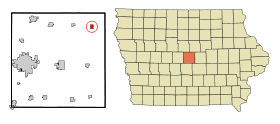
La ville américaine de Zearing est située dans le comté de Story, dans l’État de l’Iowa. Elle comptait 617 habitants en 2000.
Histoire
La localité a été nommée en hommage au juge William Mitchell Zearing, originaire de Chicago, qui avait fait don d’une cloche à la première église.
Celebration
La ville célèbre festival Jours Zearing célébration au cours de la dernière fin de semaine en juillet[1],[2].
Notes et références
Source
Wikimedia Foundation.
2010.
Contenu soumis à la licence CC-BY-SA. Source : Article Zearing de Wikipédia en français (auteurs)
Regardez d'autres dictionnaires:
Zearing — Zearing, IA U.S. city in Iowa Population (2000): 617 Housing Units (2000): 249 Land area (2000): 0.744788 sq. miles (1.928992 sq. km) Water area (2000): 0.000000 sq. miles (0.000000 sq. km) Total area (2000): 0.744788 sq. miles (1.928992 sq. km)… … StarDict's U.S. Gazetteer Places
Zearing, IA — U.S. city in Iowa Population (2000): 617 Housing Units (2000): 249 Land area (2000): 0.744788 sq. miles (1.928992 sq. km) Water area (2000): 0.000000 sq. miles (0.000000 sq. km) Total area (2000): 0.744788 sq. miles (1.928992 sq. km) FIPS code:… … StarDict's U.S. Gazetteer Places
Zearing (Iowa) — Zearing Ciudad de los Estados Unidos … Wikipedia Español
Zearing, Iowa — Infobox Settlement official name = Zearing, Iowa settlement type = City nickname = motto = imagesize = image caption = image imagesize = image caption = image mapsize = 250px map caption = Location of Zearing, Iowa mapsize1 = map caption1 =… … Wikipedia
50278 — Zearing, Ia (Miscellaneous » ZIP Codes) … Abbreviations dictionary
Kankakee Belt Route — The Kankakee Belt Route is the nickname for the Illinois Division of the New York Central Railroad, which extended from South Bend, Indiana, through Kankakee, Illinois, and westward to Zearing, Illinois. This line was sometimes referred to as the … Wikipedia
Lincoln Township, Story County, Iowa — Infobox Settlement official name = Lincoln Township settlement type = Township nickname = motto = imagesize = image caption = image imagesize = image caption = image mapsize = map caption = Location in Story County mapsize1 = map caption1 =… … Wikipedia
Story County, Iowa — Infobox U.S. County county = Story County state = Iowa seallink = map size = 250 founded = seat = Nevada largest city = Ames area total sq mi = 574 area total km2 = 1486 area land sq mi = 573 area land km2 = 1484 area water sq mi = 1 area water… … Wikipedia
Cherry, Illinois — Coordinates: 41°25′36″N 89°12′45″W / 41.42667°N 89.2125°W / 41.42667; 89.2125 … Wikipedia
Dalzell, Illinois — Coordinates: 41°21′22″N 89°10′25″W / 41.35611°N 89.17361°W / 41.35611; 89.17361 … Wikipedia
 États-Unis
 Iowa
Iowa