Westbere
- Westbere
-
51°18′34″N 1°8′28″E / 51.30944, 1.14111
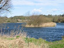
Westbere lake, avec le village de Westbere en arrière-plan
Westbere est un petit village dans le comté du Kent, entre Canterbury et l'île de Thanet. Le village est une zone de préservation qui surplombe Westbere lakes (créé par l'extraction de gravier) qui regorgent d'oiseaux, et utilisés par The King's School pour l'aviron et la voile.
Voir aussi
Sur les autres projets Wikimedia :
Wikimedia Foundation.
2010.
Contenu soumis à la licence CC-BY-SA. Source : Article Westbere de Wikipédia en français (auteurs)
Regardez d'autres dictionnaires:
Westbere — infobox UK place country = England official name= Westbere latitude= 51.3094longitude= 1.1411population = civil parish= shire district= City of Canterbury shire county= Kent region= South East Englandconstituency westminster= Canterbury post town … Wikipedia
City of Canterbury — For the settlement within the City of Canterbury, see Canterbury. For the local government area in Australia, see City of Canterbury (New South Wales). City of Canterbury Non metropolitan district, Borough, City … Wikipedia
Charles Warren — For other people named Charles Warren, see Charles Warren (disambiguation). General Sir Charles Warren … Wikipedia
The King's School, Canterbury — Infobox UK school name = The King s School size = 100px latitude = longitude = dms = motto = motto pl = established = 597 approx = closed = c approx = type = Public School religion = Church of England president = head label = Headmaster head =… … Wikipedia
Canterbury — For the larger local government district, see City of Canterbury. For other uses, see Canterbury (disambiguation). Coordinates: 51°16′30″N 1°05′13″E / 51.275°N 1.0 … Wikipedia
River Stour, Kent — Infobox River river name = River Stour image size = caption = River Stour and Tributaries origin = Postling and Lenham mouth = Pegwell Bay basin countries = length = elevation = mouth elevation = discharge = watershed = The River Stour… … Wikipedia
Chartham — Coordinates: 51°15′18″N 1°01′14″E / 51.255°N 1.0205°E / 51.255; 1.0205 … Wikipedia
Chartham Hatch — Coordinates: 51°15′18″N 1°01′14″E / 51.255°N 1.0205°E / 51.255; 1.0205 … Wikipedia
Hampstead School — Infobox UK school name = Hampstead School size = latitude = longitude = dms = motto = Learning together, achieving together motto pl = established = 1862 approx = closed = c approx = type = Comprehensive religion = president = head label =… … Wikipedia
Marshside, Kent — Coordinates: 51°21′03″N 1°11′35″E / 51.3508°N 1.1931°E / 51.3508; 1.1931 … Wikipedia

