Tidal Basin (Washington, D.C.)
- Tidal Basin (Washington, D.C.)
-
38° 53′ 01″ N 77° 02′ 20″ W / 38.88372, -77.03886

Le
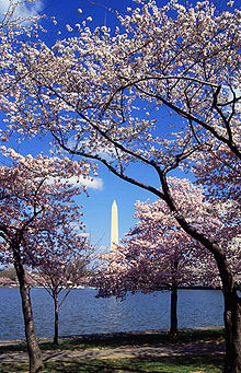
(en)« Tidal Basin » avec des cerisiers en fleur
Le (en)« Tidal Basin » est un bras de rivière partiellement aménagé par l'homme, adjacent à la rivière Potomac à Washington, D.C. Il fait partie du Parc de Potomac Ouest et est entouré par le Jefferson Memorial et du Franklin Delano Roosevelt Memorial. Le bassin couvre une aire d'à peu près 107 acres (0,433 km2) et a 10 pieds (3,048 m) de profondeur.
Le concept du (en)« Tidal Basin » date des années 1880 pour servir à la fois de pièce d'eau et de bassin de contention du Canal Washington, un port séparé de la rivière Potomac par des terres émergées où se situe le Parc de Potomac Est. Peter Conover Hains, un officier ingénieur de l'Armée US, en supervisa la conception et la construction.

Le
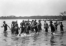
(en)« Tidal Basin » dans les années 1920

Orphelins jouant dans le
(en)« Tidal Basin » circa 1924
Notes
(en) Cet article est partiellement ou en totalité issu de l’article en anglais intitulé « Tidal Basin » (voir la liste des auteurs)
Wikimedia Foundation.
2010.
Contenu soumis à la licence CC-BY-SA. Source : Article Tidal Basin (Washington, D.C.) de Wikipédia en français (auteurs)
Regardez d'autres dictionnaires:
Tidal Basin, Washington DC — Le (en)« Tidal Basin » avec des cerisiers en fleur Le … Wikipédia en Français
Tidal Basin (District of Columbia) — The Tidal Basin is a partially man made inlet adjacent to the Potomac River in Washington, D.C. It is part of West Potomac Park and is surrounded by the Jefferson Memorial and the Franklin Delano Roosevelt Memorial. The basin covers an area of… … Wikipedia
Washington, D.C. — This article is about the place. For the novel, see Washington, D.C. (novel). Washington, D.C. Federal district … Wikipedia
Washington — /wosh ing teuhn, waw shing /, n. 1. Booker T(aliaferro) /book euhr tol euh veuhr/, 1856 1915, U.S. reformer, educator, author, and lecturer. 2. George, 1732 99, U.S. general and political leader: 1st president of the U.S. 1789 97. 3. Martha… … Universalium
Washington Channel — The Washington Channel parallels the Potomac River in Washington, D.C. It is about three miles long and joins the Anacostia River near Hains Point at its south end to connect to the Potomac River. The north end receives outflow from the Tidal… … Wikipedia
Tidal power — Tidal power, sometimes called tidal energy, is a form of hydropower that converts the energy of tides into electricity or other useful forms of power.Although not yet widely used, tidal power has potential for future electricity generation. Tides … Wikipedia
Ohio Drive (Washington, D.C.) — Ohio Drive is a street in Southwest Washington, DC, located in East and West Potomac Parks, straddling along the Tidal Basin, Washington Channel, and the Potomac River. Unlike most roads named after states in Washington, Ohio Drive is not an… … Wikipedia
Tidal acceleration — is an effect of the tidal forces between an orbiting natural satellite ( i.e. a moon), and the planet (called the primary) that it orbits. It causes a gradual recession of a satellite in a prograde orbit away from the primary, and a corresponding … Wikipedia
National Register of Historic Places listings in central Washington, D.C. — Main article: National Register of Historic Places listings in Washington, D.C. This is a list of properties and districts listed on the National Register of Historic Places in the central area of Washington, D.C. For the purposes of this list… … Wikipedia
Smithsonian (Washington Metro) — Infobox Station name = Smithsonian logo size = 50px image size = image caption = address = 1200 Independence Avenue, Southwest Washington, D.C. 20004 line = other = platform = 2 side platforms tracks = 2 parking = bicycle = 2 racks passengers = 4 … Wikipedia


