Takamaka (Seychelles)
Contenu soumis à la licence CC-BY-SA. Source : Article Takamaka (Seychelles) de Wikipédia en français (auteurs)
Regardez d'autres dictionnaires:
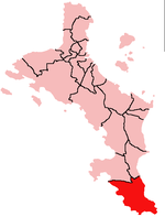
Takamaka — is one of the 22 administrative regions of Mahé, Republic of Seychelles. It is located on the southern part of the island of Mahé. (3 other districts cover the two other main islands of the Republic, Grand Anse and Baie Sainte Anne on the island… … Wikipedia
Takamaka (arbre) — Pour les articles homonymes, voir Takamaka. Takamaka … Wikipédia en Français
Takamaka — El Distrito de Takamaka en la isla de Mahe. El distrito de Takamaka se encuentra en la isla de Mahé, Seychelles. Es uno de los veinticinco districtos administrativos de la república de Seychelles. Está situado en la parte meridional de la isla.… … Wikipedia Español
Takamaka — Cette page d’homonymie répertorie les différents sujets et articles partageant un même nom. Biologie takamaka, également appelé takamaka bord de mer, est le nom donné en français dans l océan Indien à un arbre de bord de mer (Calophyllum… … Wikipédia en Français
Seychelles — Republic of Seychelles Repiblik Sesel République des Seychelles … Wikipedia
Seychelles — /say shel , shelz /, n. (used with a pl. v.) a republic consisting of 115 islands in the Indian Ocean, NE of Madagascar: a member of the Commonwealth of Nations. 78,142; 175 sq. mi. (455 sq. km). Cap.: Victoria. * * * Seychelles Introduction… … Universalium
Seychelles — Repiblik Sesel République des Seychelles Republic of Seychelles República de las Seychelles … Wikipedia Español
Seychelles — <p></p> <p></p> Introduction ::Seychelles <p></p> Background: <p></p> A lengthy struggle between France and Great Britain for the islands ended in 1814, when they were ceded to the latter.… … The World Factbook
Districts of Seychelles — … Wikipedia
Praslin (Seychelles) — 4°19′S 55°44′E / 4.317, 55.733 … Wikipédia en Français
 Pour les articles homonymes, voir Takamaka.
 Le district de Takamaka se situe à la pointe sud de l'île de Mahé.
