Sycan
- Sycan
-
42° 27′ 40″ N 121° 17′ 09″ W / 42.46111, -121.28583
La rivière Sycan (Sycan River en anglais) est une rivière qui s'écoule dans le sud-ouest de l’État de l’Oregon aux États-Unis.
Description
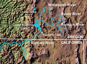
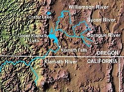
La rivière Sycan est un affluent de la rivière Sprague qui s’écoule sur environ 80 km dans l’Oregon. Elle prend sa source dans le marais Sycan, une vaste zone humide protégée au sein de la forêt nationale de Fremont au sud du comté de Lake à une soixantaine de kilomètres au nord-ouest de la localité de Lakeview. À la sortie du marais, la rivière descend rapidement au travers d’un canyon creusé dans un plateau volcanique aride connu sous le nom de "The Tablelands" à l’est de la chaîne des Cascades. Elle conflue dans la rivière Sprague au nord de Beatty à un peu moins de cinquante kilomètres au nord-est de Klamath Falls.
Wikimedia Foundation.
2010.
Contenu soumis à la licence CC-BY-SA. Source : Article Sycan de Wikipédia en français (auteurs)
Regardez d'autres dictionnaires:
Sycan River — The Sycan River is a tributary of the Sprague River, approximately 50 mi (80 km) long, in southwestern Oregon in the United States. The headwaters are in the Sycan Marsh, a vast wetlands and Nature Conservancy preserve within the Fremont National … Wikipedia
Saxon Sycan Airport — is a private airport located 21 miles south of Silver Lake in Lake County, Oregon, USA.External links … Wikipedia
OC&E Woods Line State Trail — OC E Trail through Klamath Falls at Wiard Park … Wikipedia
Climate change in Australia — Climate change has become a major issue in Australia due to drastic climate events since the turn of the 21st century that have focused government and public attention.[1] Rainfall in Australia has increased slightly over the past century,… … Wikipedia
List of rivers of Oregon — This is a partial listing of rivers in the state of Oregon, United States of America. The list of Oregon rivers is organized alphabetically and by tributary structure. The list may also include streams known as creeks, brooks, forks, branches and … Wikipedia
Eastern Cascades Slopes and Foothills (ecoregion) — The Eastern Cascades Slopes and Foothills ecoregion is a Level III ecoregion designated by the United States Environmental Protection Agency (EPA) in the U.S. states of Oregon, Washington, and California. In the rain shadow of the Cascade Range,… … Wikipedia
Chaîne des Cascades — Ne doit pas être confondu avec Arc volcanique des Cascades. Chaîne des Cascades Carte topographique de la chaîne des Cascades … Wikipédia en Français
List of National Wild and Scenic Rivers — This is a list of the designated National Wild and Scenic Rivers in the United States. Some rivers may be listed more than once if they have designated sections in different states.Initials of the managing agency follow the name of the river.… … Wikipedia
Beatty, Oregon — Beatty is an unincorporated community in Klamath County, Oregon, United States. Beatty is located on Oregon Route 140 at the confluence of the Sycan and Sprague Rivers and is 30 miles east of Klamath Falls.Beatty was named for J .L. Beatty, a… … Wikipedia
Klamath Basin — Counties in California. WatershedThe Klamath Basin watershed includes: * Sprague River, Oregon * Williamson River, Oregon * Sycan River, Oregon * Upper Klamath Lake, Oregon * Link River, Oregon * Agency Lake, Oregon * Lost River, Oregon,… … Wikipedia
 États-Unis