Swanton (village)
- Swanton (village)
-
44° 55′ 11″ N 73° 07′ 16″ W / 44.919722, -73.121111
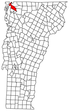
Swanton est un village à l'intérieur de la municipalité de Swanton dans l'État du Vermont aux États-Unis. Sa population était de 2 548 en 2000[1].
Le nom du village provient probablement du nom d'un officier britannique, le capitaine William Swanton, ou du village de Swanton, près de Maidstone dans le comté anglais du Kent. Swanton est une des rares places au Vermont ou les amérindiens ont une résidence permanente. De 1700 à 1758, l'important village Abenaki de Missisiasuk était situé sur la rivière Missisquoi. Le nom du village, qui veut dire "le peuple de la grande prairie herbale", nous aident à la traduction du nom Missiquoi qui veut dire "grande prairie herbale". Le nom Abenaki pour l'embouchure de la rivière était Maskwenozakek, qui veut dire "l'endroit ou le maskinongé abondes", qui aurait une raison suffisante pour établire un village tout près[2].
Démographie
D'après le bureau de recensement américain, 38% de la population de Swanton sont d'origine Canadienne-française, 12% Irlandais, 10 % Anglais et 9% Amérindiens[3].
Liens externes
Références
44° 54′ 35″ N 73° 07′ 14″ W / 44.90972, -73.12056
Wikimedia Foundation.
2010.
Contenu soumis à la licence CC-BY-SA. Source : Article Swanton (village) de Wikipédia en français (auteurs)
Regardez d'autres dictionnaires:
Swanton (village), Vermont — Infobox Settlement official name = Swanton, Vermont settlement type = Village nickname = motto = imagesize = image caption = image |pushpin pushpin label position =left pushpin map caption =Location within the state of Vermont pushpin mapsize =… … Wikipedia
Swanton (Vermont) — 44° 54′ 35″ N 73° 07′ 14″ W / 44.90972, 73.12056 … Wikipédia en Français
Swanton — Swanton, NE U.S. village in Nebraska Population (2000): 106 Housing Units (2000): 59 Land area (2000): 0.199194 sq. miles (0.515910 sq. km) Water area (2000): 0.000000 sq. miles (0.000000 sq. km) Total area (2000): 0.199194 sq. miles (0.515910 sq … StarDict's U.S. Gazetteer Places
Swanton, NE — U.S. village in Nebraska Population (2000): 106 Housing Units (2000): 59 Land area (2000): 0.199194 sq. miles (0.515910 sq. km) Water area (2000): 0.000000 sq. miles (0.000000 sq. km) Total area (2000): 0.199194 sq. miles (0.515910 sq. km) FIPS… … StarDict's U.S. Gazetteer Places
Swanton, OH — U.S. village in Ohio Population (2000): 3307 Housing Units (2000): 1292 Land area (2000): 2.382485 sq. miles (6.170608 sq. km) Water area (2000): 0.000000 sq. miles (0.000000 sq. km) Total area (2000): 2.382485 sq. miles (6.170608 sq. km) FIPS… … StarDict's U.S. Gazetteer Places
Swanton, VT — U.S. village in Vermont Population (2000): 2548 Housing Units (2000): 1064 Land area (2000): 0.758718 sq. miles (1.965071 sq. km) Water area (2000): 0.031816 sq. miles (0.082404 sq. km) Total area (2000): 0.790534 sq. miles (2.047475 sq. km) FIPS … StarDict's U.S. Gazetteer Places
Swanton, Ohio — Infobox Settlement official name = Swanton, Ohio settlement type = Village nickname = motto = imagesize = image caption = image mapsize = 250x200px map caption = Location of Swanton, Ohio mapsize1 = map caption1 = subdivision type = Country… … Wikipedia
Swanton, Nebraska — Infobox Settlement official name = Swanton, Nebraska settlement type = Village nickname = motto = imagesize = image caption = image imagesize = image caption = image mapsize = 250px map caption = Location of Swanton, Nebraska mapsize1 = map… … Wikipedia
Swanton Morley — Infobox UK place country = England latitude = 52.70864 longitude = 0.98131 official name = Swanton Morley population = shire district = Breckland shire county = Norfolk region = East of England constituency westminster = Mid Norfolk post town =… … Wikipedia
Swanton Novers — Infobox UK place official name= Swanton Novers country= England region= East of England shire district= North Norfolk shire county= Norfolk civil parish= Swanton Novers CP static static image caption =Saint Edmund Parish Church, Swanton Novers… … Wikipedia
 États-Unis
 Vermont