Santiváñez

Santiváñez

17° 33′ S 66° 15′ W / -17.55, -66.25


Santiváñez
Administration
Pays Drapeau de Bolivie Bolivie
Département Flag of cochabamba.svg Cochabamba
Province Capinota
Géographie
Coordonnées 17° 33′ Sud
       66° 15′ Ouest
/ -17.55, -66.25
Démographie
Population 1 400 hab. (2010)
Localisation
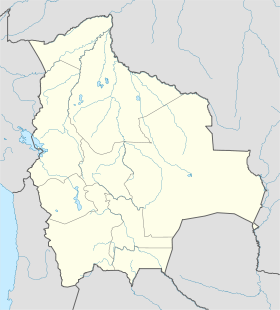
Bolivia location map.svg
City locator 14.svg
Santiváñez
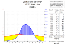
diagramme températures/précipitations annuel

Santiváñez est une localité du département de Cochabamba en Bolivie, située dans la Province de Capinota et la municipalité de Santiváñez. Sa population était estimée à 1 400 habitants en 2010[1].

Sommaire

Localisation

Santiváñez est située sur un des grands plateaux fertiles de 490 km2carrés de la Valle Alto, à une altitude de 2554 m et 17 km à l'ouest du lac de La Angostura, le plus grand lac en Bolivie.

Géographie

Santiváñez est dans la zone de transition entre le versant bolivien de la cordillère des Andes, la Cordillière Centrale, et les plaines boliviennes. La température moyenne de la région est d'environ 18 °C et ne varie que légèrement entre 14 °C en juin / juillet et 20 °C en octobre / novembre. Les précipitations annuelles est seulement d'environ 450 mm, avec une saison sèche marquée de mai à septembre, des précipitations mensuelles inférieures à 10 mm et une humidité relative de décembre à février avec des précipitations de 90 mm à 120 mois.

Réseau de communications

Population

La population a évolué entre 1992 et 2010 comme suit :

  • 1992 : 928 habitants (recensement)[2]
  • 2001 : 1 046 habitants (recensement)[3]
  • 2010 : 1 400 habitants (estimation)[1]

Références

Liens externes


Wikimedia Foundation. 2010.

Contenu soumis à la licence CC-BY-SA. Source : Article Santiváñez de Wikipédia en français (auteurs)

Игры ⚽ Поможем написать курсовую

Regardez d'autres dictionnaires:

  • Santiváñez — Basisdaten Einwohner (Stand) 1400 Einw. (Fortschreibung 2010) [1] Höhe 2.554 m Tele …   Deutsch Wikipedia

  • Santiváñez (Municipio) — Municipio Santiváñez Basisdaten Einwohner (Stand)  Bevölkerungsdichte 6717 Einw. (Fortschreibung 2010)[1] 23 Einw./km² Telefonvorwahl (+591) Fläche 297 …   Deutsch Wikipedia

  • Anita Santivañez — Saltar a navegación, búsqueda Anita Santivañez Información personal Nombre real Ana María Santivañez Palomino …   Wikipedia Español

  • Rafael Marquina y Bueno — Saltar a navegación, búsqueda Para otros usos de este término, véase Marquina. Rafael Marquina y Bueno Información personal Nombre Rafael Marquina Nacimiento 9 de febrero de 1884 Lima, Perú …   Wikipedia Español

  • Liste der Verwaltungseinheiten von Bolivien — Der südamerikanische Binnenstaat Bolivien gliedert sich in: 9 Departamentos 112 Provinzen (Provincias) 337 Landkreise (Municipios) 1374 Kantone (Cantones) Inhaltsverzeichnis 1 Departamento Beni …   Deutsch Wikipedia

  • Movimiento Hora Zero — El Movimiento Hora Zero fue el más importante movimiento vanguardista de poesía surgido en la década del setenta, en el siglo XX, en Perú. Jorge Pimentel, Juan Ramírez Ruiz, Tulio Mora, Enrique Verástegui, Jorge Nájar y Carmen Ollé son… …   Wikipedia Español

  • Desamparados station — Main facade of the Desamparados station The Desamparados station (Spanish: Estación de Desamparados) is an old railway station in Lima, Peru. It is situated on the left margin of the Rímac River, next to the Government Palace. The station was… …   Wikipedia

  • Torneo Intermedio 2011 — Torneo Intermedio Perú 2011 Cantidad de equipos 32 Sede  Perú Fecha …   Wikipedia Español

  • Liste des divisions administratives de la Bolivie — La Bolivie comporte sept niveaux de divisions administratives : L État bolivien; les départements, deuxièmes niveaux, au nombre de 9; Les provinces (provincia en espagnol), troisièmes niveaux, au nombre de 112; Les municipalités (municipio… …   Wikipédia en Français

  • Cochabamba Department — For other uses, see Cochabamba (disambiguation). Department of Cochabamba Quchapampa suyu Flag …   Wikipedia

Share the article and excerpts

Direct link
Do a right-click on the link above
and select “Copy Link”