Réservoir Wickiup
- Réservoir Wickiup
-
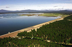
Le réservoir Wickiup (Wickiup Reservoir) est un lac artificiel situé dans l'Oregon dans le comté de Deschutes.
Description
Le lac est localisé à environ 100 km au sud-ouest de la localité de Bend[1] à l'intérieur de la forêt nationale de Deschutes.
Le lac est nait suite à la construction en 1949 du barrage Wickiup sur la rivière Deschutes. Le barrage fait environ 4 km de long et le lac a une superficie totale de 45 km2[2]. Sa profondeur moyenne est de 6 m alors qu'elle peut atteindre au maximum 21 m[1]. La zone est appréciée des touristes pour la pêche, pour les sports nautiques et plusieurs campings sont présents à proximité[3],[1].
Références
Wikimedia Foundation.
2010.
Contenu soumis à la licence CC-BY-SA. Source : Article Réservoir Wickiup de Wikipédia en français (auteurs)
Regardez d'autres dictionnaires:
Wickiup Reservoir — Sp Vikiapo tvenkinỹs Ap Wickiup Reservoir L Dišiutso u., JAV (Oregonas) … Pasaulio vietovardžiai. Internetinė duomenų bazė
Chaîne des Cascades — Ne doit pas être confondu avec Arc volcanique des Cascades. Chaîne des Cascades Carte topographique de la chaîne des Cascades … Wikipédia en Français
List of dams and reservoirs in the United States — This list is incomplete; you can help by expanding it. The following is a partial list of dams and reservoirs in the United States. There are an estimated 75,000 dams in the United States, impounding 600,000 mi (970,000 km) of river or about 17%… … Wikipedia
List of reservoirs and dams in the United States — There are an estimated 75,000 dams in the United States, blocking 600,000 miles (960,000 km) of river or about 17% of rivers in the nation . [cite web|url=http://www.pcffa.org/dams.htm |title=Dams and salmon |accessdate=2008 02 11] The following… … Wikipedia
Deschutes River (Oregon) — This article is about the river in Oregon. For other uses, see Deschutes (disambiguation). Coordinates: 45°38′07″N 120°54′52″W / 45.63528°N 120.91444°W … Wikipedia
Deschutes County — Verwaltung US Bundesstaat: Oregon Verwaltungssitz: Bend Gründung: 1916 Demographie Einwohner: 115.367 … Deutsch Wikipedia
Cascade Lakes Scenic Byway — Forest Route 46 Cascade Lakes Scenic Byway shown highlighted in gree … Wikipedia
Century Drive Highway — infobox road state=OR highway name=Century Drive Highway The Century Drive Highway No. 372 (see Oregon highways and routes) is a state highway in the U.S. state of Oregon. It runs from the city of Bend to the Mount Bachelor ski area, and is… … Wikipedia
dietary law — Judaism. law dealing with foods permitted to be eaten, food preparation and combinations, and the utensils and dishes coming into contact with food. Cf. kashruth. [1925 30] * * * ▪ religion Introduction any of the prescriptions as to what… … Universalium
Vikiapo tvenkinys — Sp Vikiapo tvenkinỹs Ap Wickiup Reservoir L Dišiutso u., JAV (Oregonas) … Pasaulio vietovardžiai. Internetinė duomenų bazė
 États-Unis
 Oregon
