Riverside Geyser

Riverside Geyser
Riverside Geyser
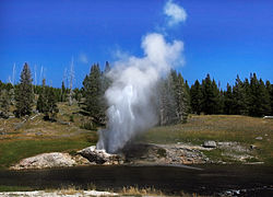
Le Riverside Geyser en éruption.
Localisation
Pays Drapeau des États-Unis États-Unis
État Wyoming
Comté Teton
Aire protégée Parc national de Yellowstone
Coordonnées géographiques 44° 28′ 25″ N 110° 50′ 26″ W / 44.47354, -110.8404844° 28′ 25″ N 110° 50′ 26″ W / 44.47354, -110.84048
Caractéristiques
Température 82,1°C
Profondeur 22 m
Durée 20 minutes
Fréquence 5 à 7 heures

Géolocalisation sur la carte : Wyoming

(Voir situation sur carte : Wyoming)
Riverside Geyser

Géolocalisation sur la carte : États-Unis

(Voir situation sur carte : États-Unis)
Riverside Geyser

Le Riverside Geyser est un geyser dans le parc national de Yellowstone, aux États-Unis.

Il est situé au bord de la rivière Firehole, dans le bassin géothermique Upper Geyser Basin. Il crache de la vapeur et un jet d'eau pouvant atteindre 23 mètres. Le jet d'eau forme un arc au-dessus de la rivière et peut créer un arc-en-ciel brillant. Les éruptions sont espacées de cinq heures et demi à sept heures. De même que Daisy Geyser, Riverside est un des geysers les plus prévisibles du parc national, car il est relativement isolé, à l'écart d'autres geysers qui pourraient perturber la circulation de l'eau dans ses canalisations souterraines.

Vidéo du Riverside Geyser en éruption.

Référence

Lien externe

Sur les autres projets Wikimedia :


Wikimedia Foundation. 2010.

Contenu soumis à la licence CC-BY-SA. Source : Article Riverside Geyser de Wikipédia en français (auteurs)

Игры ⚽ Нужно сделать НИР?

Regardez d'autres dictionnaires:

  • Riverside Geyser — is a geyser in Yellowstone National Park in the U.S. state of Wyoming.The geyser is located on the Firehole River within the Upper Geyser Basin. The geyser shoots steam and water to heights of 75 feet (23 m) in an arch over the river. The… …   Wikipedia

  • Geyser — For other uses, see Geyser (disambiguation). Strokkur geyser, Iceland …   Wikipedia

  • Riverside State Park — The Bowl and Pitcher formation. Location Spokane County, Washington, USA …   Wikipedia

  • Daisy Geyser — during an eruption …   Wikipedia

  • Comet Geyser — Location Upper Geyser Basin, Yellowstone National Park, Teton County, Wyoming Coordinates …   Wikipedia

  • Upper Geyser Basin — Das obere Geysir Becken (engl.: Upper Geyser Basin), auch Old Faithful Region genannt, ist die Region im Yellowstone Nationalpark, welche die höchste Konzentration von geothermalen Objekten im Park aufweist. Sie liegt am Rande der Yellowstone… …   Deutsch Wikipedia

  • Fan and Mortar Geysers — Mortar in the foreground, and Fan in the background Name origin Fan Washburn Party (1870) Mortar Frank Jay Haynes (1883) Coordinates …   Wikipedia

  • Geothermal areas of Yellowstone — Map of all coordinates from Google Map of all coordinates from Bing Export all coordinates as KML …   Wikipedia

  • List of Yellowstone geothermal features — This is a list of geysers in Yellowstone National Park.A* A 0 Geyser *Abyss Pool * Anemone Geyser * Artemisia Geyser * Artesia Geyser * Atomizer Geyser * Aurum Geyser *Azure SpringB*Baby Daisy Geyser * Beach Geyser * Bead Geyser * Beauty Pool *… …   Wikipedia

  • Old Faithful — redirects here. For other uses, see Old Faithful (disambiguation). Old Faithful Eruption of Old Faithful …   Wikipedia

Share the article and excerpts

Direct link
Do a right-click on the link above
and select “Copy Link”