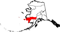
Bethel Census Area
- Bethel Census Area
-
Région de recensement de Bethel
| Bethel Census Area, Alaska |
|
 |
| Administration |
| Pays |
 États-Unis États-Unis |
| État |
 Alaska Alaska |
| Chef-lieu |
Aucun |
| Fondation |
? |
| Caractéristiques |
| Superficie |
| Totale |
117 866 km² |
| Terre |
105 240 km² |
| Eau |
12 626 km² (10,71 %) |
| Population |
| Totale (recens. 2000) |
16 006 hab. |
| Densité |
0,15 hab./km² |
La région de recensement de Bethel (Bethel Census Area en anglais) est une région de recensement de l'État d'Alaska aux États-Unis, partie du borough non-organisé.
Villes
- Akiachak,
- Akiak,
- Aniak,
- Atmautluak,
- Bethel,
- Chefornak,
- Chuathbaluk,
- Crooked Creek,
- Crow Village,
- Eek,
- Georgetown,
- Goodnews Bay,
- Kasigluk,
- Kipnuk,
- Kongiganak,
- Kwethluk,
- Kwigillingok,
- Lime Village,
- Lower Kalskag,
- Mekoryuk,
- Napaimute,
- Napakiak,
- Napaskiak,
- Newtok,
- Nightmute,
- Nunapitchuk,
- Oscarville,
- Platinum,
- Quinhagak,
- Red Devil,
- Sleetmute,
- Stony River,
- Toksook Bay,
- Tuluksak,
- Tuntutuliak,
- Tununak,
- Upper Kalskag,
Catégorie : Subdivision d'Alaska
Wikimedia Foundation.
2010.
Contenu soumis à la licence CC-BY-SA. Source : Article Bethel Census Area de Wikipédia en français (auteurs)
Regardez d'autres dictionnaires:
Bethel Census Area — Der Bethel Census Area ist ein Census Area im US Bundesstaat Alaska. Er erstreckt sich von der Küste der Bristol Bay und dem Yukon Kuskokwim Delta landeinwärts und beinhaltet die Insel Nunivak im Beringmeer. Im Jahr 2010 betrug die… … Deutsch Wikipedia
Bethel Census Area — Admin ASC 2 Code Orig. name Bethel Census Area Country and Admin Code US.AK.050 US … World countries Adminstrative division ASC I-II
Bethel Census Area, Alaska — Bethel Census Area is a census area located in the U.S. state of Alaska. As of 2000, the population is 16,006. It is part of the unorganized borough and therefore has no borough seat. Its largest community by far is the city of Bethel, which also … Wikipedia
National Register of Historic Places listings in Bethel Census Area, Alaska — Location of the Bethel Census Area in Alaska This is a list of the National Register of Historic Places listings in Bethel Census Area, Alaska. This is intended to be a complete list of the properties and districts on the National Register of… … Wikipedia
Liste der Registered Historic Places im Bethel Census Area — Die Liste der Registered Historic Places im Bethel Census Area führt alle Bauwerke und historischen Stätten im Bethel Census Area des US Bundesstaates Alaska auf, die in das National Register of Historic Places aufgenommen wurden.… … Deutsch Wikipedia
Dillingham Census Area, Alaska — Dillingham Census Area is a census area located in the state of Alaska, United States. As of the 2000 census, the population was 4,922. It is part of the unorganized borough and therefore has no borough seat. Its largest community by far is the… … Wikipedia
Prince of Wales-Outer Ketchikan Census Area — Prince of Wales Hyder Census Area (seit 19. Mai 2008) Prince … Deutsch Wikipedia
Prince of Wales - Outer Ketchikan Census Area — Prince of Wales Hyder Census Area (seit 19. Mai 2008) Prince … Deutsch Wikipedia
Skagway-Hoonah-Angoon Census Area — Hoonah Angoon Census Area (seit 5. Juni 2007) Skagway Hoonah Angoon Census Area (von 1992 bi … Deutsch Wikipedia
Skagway-Yakutat-Angoon Census Area — Hoonah Angoon Census Area (seit 5. Juni 2007) Skagway Hoonah Angoon Census Area (von 1992 bi … Deutsch Wikipedia

